Difference between revisions of "2016-05-05 49 11"
From Geohashing
imported>Klaus (expedition) |
imported>Klaus m (no trespassing) |
||
| Line 41: | Line 41: | ||
== Photos == | == Photos == | ||
| − | |||
| − | |||
| − | |||
| − | |||
<gallery perrow="5"> | <gallery perrow="5"> | ||
| + | Image:2016-05-05 49 11 proof.png | closest I got | ||
</gallery> | </gallery> | ||
== Achievements == | == Achievements == | ||
{{#vardefine:ribbonwidth|800px}} | {{#vardefine:ribbonwidth|800px}} | ||
| − | |||
| + | {{No trespassing | ||
| + | | latitude = 49 | ||
| + | | longitude = 11 | ||
| + | | date = 2016-05-05 | ||
| + | | name = [[User:Klaus|Klaus]] | ||
| + | | image = 2016-05-05 49 11 proof.png | ||
| + | | distance = 35m | ||
| + | }} | ||
[[Category:Expeditions]] | [[Category:Expeditions]] | ||
Revision as of 13:46, 18 May 2016
| Thu 5 May 2016 in 49,11: 49.9130918, 11.1188644 geohashing.info google osm bing/os kml crox |
Location
between Laibaroes und Geisdorf
Participants
Plans
short cycling tour there in the afternoon, starting from my parents home
Expedition
I cycled only 5km, and it was done in Tron style. However, I didn't go to the exact location because of crops on the field and was only able to approach only 72m from the street.
So this has to be considered as a failed one.
In Geisdorf was "Glockenturmfest" and a lot of people were cycling/driving near the geohash on the street to this very small village.
Tracklog
maybe will follow, will have to draw it on a map
Photos
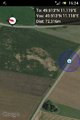
closest I got

Achievements
Klaus earned the No trespassing consolation prize
|