Difference between revisions of "2017-01-03 55 37"
From Geohashing
imported>Dunaril ([live] We hit the geohash, according to Geohash Droid. A few pics below are all the proof I have but I definitely got into GPS uncertainty. This is completely crazy!) |
imported>Dunaril |
||
| Line 27: | Line 27: | ||
== Plans == | == Plans == | ||
<!-- what were the original plans --> | <!-- what were the original plans --> | ||
| + | *Attempting a driving geohash. Google Maps indicates it to be on the other side of the road I am currently taking to the airport. It should be within the GPS uncertainty range. -- [[User:Dunaril|Dunaril]] ([[User talk:Dunaril|talk]]) [http://www.openstreetmap.org/?lat=55.86458350&lon=37.46387620&zoom=16&layers=B000FTF @55.8646,37.4639] 12:04, 3 January 2017 (GMT+03:00) | ||
== Expedition == | == Expedition == | ||
<!-- how it all turned out. your narrative goes here. --> | <!-- how it all turned out. your narrative goes here. --> | ||
| − | |||
| − | |||
| − | |||
*We hit the geohash, according to Geohash Droid. A few pics below are all the proof I have but I definitely got into GPS uncertainty. This is completely crazy! -- [[User:Dunaril|Dunaril]] ([[User talk:Dunaril|talk]]) 12:15, 3 January 2017 (GMT+03:00) | *We hit the geohash, according to Geohash Droid. A few pics below are all the proof I have but I definitely got into GPS uncertainty. This is completely crazy! -- [[User:Dunaril|Dunaril]] ([[User talk:Dunaril|talk]]) 12:15, 3 January 2017 (GMT+03:00) | ||
| Line 55: | Line 53: | ||
<!-- =============== USEFUL CATEGORIES FOLLOW ================ | <!-- =============== USEFUL CATEGORIES FOLLOW ================ | ||
Delete the next line ONLY if you have chosen the appropriate categories below. If you are unsure, don't worry. People will read your report and help you with the classification. --> | Delete the next line ONLY if you have chosen the appropriate categories below. If you are unsure, don't worry. People will read your report and help you with the classification. --> | ||
| − | + | ||
<!-- ==REQUEST FOR TWITTER BOT== Please leave either the New report or the Expedition planning category in as long as you work on it. This helps the twitter bot a lot with announcing the right outcome at the right moment. --> | <!-- ==REQUEST FOR TWITTER BOT== Please leave either the New report or the Expedition planning category in as long as you work on it. This helps the twitter bot a lot with announcing the right outcome at the right moment. --> | ||
| − | + | ||
| − | |||
[[Category:Expedition planning]] | [[Category:Expedition planning]] | ||
| − | |||
| − | |||
<!-- An actual expedition: | <!-- An actual expedition: | ||
| Line 78: | Line 73: | ||
| − | + | --> | |
| − | |||
| − | |||
| − | |||
| − | |||
| − | |||
| − | |||
| − | |||
| − | |||
| − | |||
| − | |||
| − | |||
| − | |||
| − | |||
| − | |||
| − | |||
Revision as of 09:17, 3 January 2017
| Tue 3 Jan 2017 in 55,37: 55.8948450, 37.4284865 geohashing.info google osm bing/os kml crox |
Location
Participants
Plans
- Attempting a driving geohash. Google Maps indicates it to be on the other side of the road I am currently taking to the airport. It should be within the GPS uncertainty range. -- Dunaril (talk) @55.8646,37.4639 12:04, 3 January 2017 (GMT+03:00)
Expedition
- We hit the geohash, according to Geohash Droid. A few pics below are all the proof I have but I definitely got into GPS uncertainty. This is completely crazy! -- Dunaril (talk) 12:15, 3 January 2017 (GMT+03:00)
Tracklog
Photos
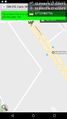
Got it! @55.8991,37.4233
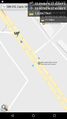
Just before. I hit 0m on Geohash Droid but was too quick to screenshot :) @55.9079,37.4109


Achievements