Difference between revisions of "2017-07-29 41 -71"
imported>Vbob (→Photos) |
imported>Vbob (→Achievements) |
||
| Line 60: | Line 60: | ||
== Achievements == | == Achievements == | ||
{{#vardefine:ribbonwidth|800px}} | {{#vardefine:ribbonwidth|800px}} | ||
| − | + | ||
| − | |||
| − | |||
| − | |||
| − | |||
| − | |||
| − | |||
| − | |||
| − | |||
| − | |||
| − | |||
| − | |||
| − | |||
| − | |||
| − | |||
| − | |||
| − | |||
| − | |||
| − | |||
| − | |||
| − | |||
| − | |||
| − | |||
| − | |||
| − | |||
| − | |||
| − | |||
| − | |||
| − | |||
| − | |||
| − | |||
| − | |||
| − | |||
{{Déjà vu geohash | {{Déjà vu geohash | ||
| latitude = 41 | | latitude = 41 | ||
Revision as of 01:15, 2 August 2017
| Sat 29 Jul 2017 in 41,-71: 41.6067425, -71.6376951 geohashing.info google osm bing/os kml crox |
Location
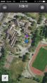
Around back of the Exeter-West Greenwich Regional High School - again.
Participants
- Vbob and
- Bruce
Plans
Realized on Friday morning that this Saturday hash was going to be a glorious sunny day [I was wrong]; and that the hash was in an interesting public place where the opportunities for Drag-Along and/or already-happened-to-be-here were good [ I was half wrong]; so trying to organize a long-overdue meet up was worthwhile.... Except I'd forgotten my wiki password; Except that the wiki engine wouldn't send me a reset email; Even though it let me create a new account and new password; It wouldn't send the new me an email to authorize us to create an expedition page.....
So the word didn't get out, and the raw weather kept the [almost] interested bystanders at home; so partner and I went anyway....
Expedition
Drove there after a lobster lunch with inlaws, outlaws and grandsons. Expected to find some random student athletes using the fields behind the school, but we didn't see another soul. Did the geohash dance under the trees, and found the hash to land in the middle of a picnic table. We were hoping it would be somewhere on the flagstones of a small ampitheater, the center of which is marked with a very nice compass rose, but that was about 100' off the hash.
Tracklog
Photos
iPhone pins us at the hash

the Grin™ x 2
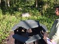
a nice bit of hash dead center on the picnic table
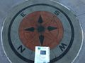
even though this would have been a perfect spot for a hash
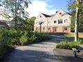
high school complex


Achievements
Vbob n' Bruce earned the Déjà Vu Geohash Achievement
|
damfino why the template won't accept or expand the 'old date' correctly.... http://wiki.xkcd.com/geohashing/2013-04-24_41_-71