Difference between revisions of "2018-09-02 51 9"
From Geohashing
imported>GeorgDerReisende (new report) |
imported>GeorgDerReisende (expedition report for Gudensberg) |
||
| Line 1: | Line 1: | ||
| − | |||
| − | |||
| − | |||
| − | |||
| − | |||
| − | |||
| − | |||
| − | |||
| − | |||
| − | |||
{{meetup graticule | {{meetup graticule | ||
| lat=51 | | lat=51 | ||
| Line 19: | Line 9: | ||
== Location == | == Location == | ||
| − | + | ||
| + | The hash lay in a garden between the streets Große Binde and Birnenallee in Gudensberg. | ||
== Participants == | == Participants == | ||
| − | + | ||
| − | + | [[User:GeorgDerReisende|GeorgDerReisende]] | |
== Plans == | == Plans == | ||
| − | + | ||
| + | Travel by public transport and a walk. | ||
== Expedition == | == Expedition == | ||
| − | + | ||
| + | I did it as planned. I took the tram and the bus 500 to Gudensberg and walked to the hash. I danced around the garden, but couldn't get nearer than 16 meters. | ||
== Tracklog == | == Tracklog == | ||
| Line 39: | Line 32: | ||
--> | --> | ||
<gallery perrow="5"> | <gallery perrow="5"> | ||
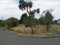
| + | Image:2018-09-02 51 9 GeorgDerReisende 1220.jpg | the garden | ||
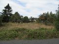
| + | Image:2018-09-02 51 9 GeorgDerReisende 1221.jpg | view from the Birnenallee | ||
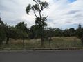
| + | Image:2018-09-02 51 9 GeorgDerReisende 1222.jpg | view from the Große Binde | ||
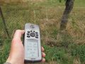
| + | Image:2018-09-02 51 9 GeorgDerReisende 1223.jpg | proof | ||
| + | Image:2018-09-02 51 9 GeorgDerReisende 1224.jpg | proof | ||
</gallery> | </gallery> | ||
| − | + | [[Category:Expeditions]] | |
| − | |||
| − | |||
| − | |||
| − | |||
| − | |||
| − | |||
| − | |||
| − | |||
| − | |||
| − | |||
| − | |||
| − | [[Category: | ||
| − | |||
| − | |||
| − | |||
| − | |||
| − | |||
| − | |||
[[Category:Expeditions with photos]] | [[Category:Expeditions with photos]] | ||
| − | |||
| − | |||
| − | |||
| − | |||
| − | |||
| − | |||
| + | [[Category:Coordinates not reached]] | ||
| − | |||
| − | |||
| − | |||
| − | |||
| − | |||
| − | |||
| − | |||
[[Category:Not reached - No public access]] | [[Category:Not reached - No public access]] | ||
| − | |||
| − | |||
| − | |||
| − | |||
| − | |||
| − | |||
| − | |||
| − | |||
Revision as of 18:11, 17 September 2018
| Sun 2 Sep 2018 in 51,9: 51.1774901, 9.3805173 geohashing.info google osm bing/os kml crox |
Location
The hash lay in a garden between the streets Große Binde and Birnenallee in Gudensberg.
Participants
Plans
Travel by public transport and a walk.
Expedition
I did it as planned. I took the tram and the bus 500 to Gudensberg and walked to the hash. I danced around the garden, but couldn't get nearer than 16 meters.
Tracklog
Photos
the garden
view from the Birnenallee
view from the Große Binde
proof
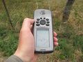
proof


