Difference between revisions of "2018-10-17 37 -122"
From Geohashing
imported>Anthony (create page) |
imported>Anthony (→Photos: captions) |
||
| Line 24: | Line 24: | ||
== Photos == | == Photos == | ||
| − | <gallery perrow=" | + | <gallery perrow="4"> |
| − | File:IMG 20181017 114553-edit.jpg | + | File:IMG 20181017 114553-edit.jpg|Looking from path towards Lawton Street. The Park Department is doing new landscaping. |
| − | File:IMG 20181017 114331-edit.jpg | + | File:IMG 20181017 114331-edit.jpg|Looking east at hashpoint. |
| − | File:IMG 20181017 114444-edit.jpg | + | File:IMG 20181017 114444-edit.jpg|Looking north towards hashpoint |
| − | File:IMG 20181017 114349-edit.jpg | + | File:IMG 20181017 114349-edit.jpg|Looking northwest towards hashpoint. Light for Lawton Street visible in distance. |
| − | File:Screenshot 20181017-114310.png | + | File:Screenshot 20181017-114310.png|Victory! |
| − | File:Screenshot 20181017-114319.png | + | File:Screenshot 20181017-114319.png|Map view. |
</gallery> | </gallery> | ||
Revision as of 18:00, 20 October 2018
| Wed 17 Oct 2018 in 37,-122: 37.7559655, -122.5090191 geohashing.info google osm bing/os kml crox |
Location
Between Great Highway (upper) and Great Highway (lower) south of Lawton Street, San Francisco
Participants
Plans
Almost none. I saw that the point was accessible to my office, so I stopped by.
Expedition
Drove to corner of Lawton and Great Highway from work. Parked. Walked along separator strip until I found the point. Walked back to car, had lunch in neighborhood, went back to work.
Track
Photos
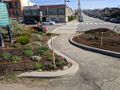
Looking from path towards Lawton Street. The Park Department is doing new landscaping.
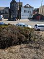
Looking east at hashpoint.
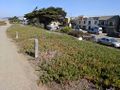
Looking north towards hashpoint
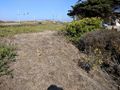
Looking northwest towards hashpoint. Light for Lawton Street visible in distance.
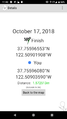
Victory!
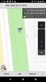
Map view.


