Difference between revisions of "2018-11-02 49 8"
imported>DODO ([live picture]The hasher. Happy.) |
imported>DODO (→Expedition) |
||
| Line 33: | Line 33: | ||
== Expedition == | == Expedition == | ||
<!-- how it all turned out. your narrative goes here. --> | <!-- how it all turned out. your narrative goes here. --> | ||
| + | Pretty much as planned. I started a little late. The weather was sunny, but there were black clouds at the horizon. As I wanted to reach a tron achievement, I started in the wrong direction but with a very small detour I reached the way to the south. After half an hour I really reached the hash - or at least apath that lead very close to it. I left my bike there and walked 6 m into a salad field, where the hash waited for me. Some pictures and some minutes later I was back on my bike. The path became very muddy for a short while, but I managed to ride through the mud without getting my feet on the ground and half an hour later I was back home. | ||
== Tracklog == | == Tracklog == | ||
Revision as of 14:28, 2 November 2018
| Fri 2 Nov 2018 in 49,8: 49.2647693, 8.3524044 geohashing.info google osm bing/os kml crox |
Location
On a field between Lingenfeld and Schwegenheim.
Participants
Plans
Go there by bike. Will start at (around) 2 pm and plan to be there half an hour later.
Expedition
Pretty much as planned. I started a little late. The weather was sunny, but there were black clouds at the horizon. As I wanted to reach a tron achievement, I started in the wrong direction but with a very small detour I reached the way to the south. After half an hour I really reached the hash - or at least apath that lead very close to it. I left my bike there and walked 6 m into a salad field, where the hash waited for me. Some pictures and some minutes later I was back on my bike. The path became very muddy for a short while, but I managed to ride through the mud without getting my feet on the ground and half an hour later I was back home.
Tracklog
Photos
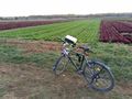
My bike. The hash is 7m in the green salad field
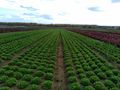
View to the south. Mord salad.
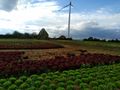
To the West. You See the Mountains oft the Pfälzerwald behind the windmill.
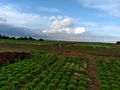
The north. My bike. Again.
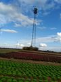
The East. A Telefon Tower.
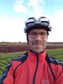
The hasher. Happy.


Achievements