Difference between revisions of "2019-04-14 51 -2"
imported>NathanielBryceson (→Tracklog) |
imported>NathanielBryceson (→Photos) |
||
| Line 57: | Line 57: | ||
--> | --> | ||
<gallery perrow="5"> | <gallery perrow="5"> | ||
| + | Image:NB Geohash 2019-04-13.jpg | My First Geohash | ||
</gallery> | </gallery> | ||
Revision as of 20:40, 13 April 2019
| Sun 14 Apr 2019 in 51,-2: 51.6625758, -2.1490940 geohashing.info google osm bing/os kml crox |
Location
Today I went on my first ever Geohashing expedition. It was in the Bristol, United Kingdom graticule.
Participants
I went with my 4x great grandson, User:Saxbophone
Plans
We went a day early to check out the location and whether it was accessible. But we recorded it anyway.
Expedition
We realised the location was in the middle of a field! We wondered if we could access via a nearby Blacksmiths business but it was closed. We then discovered a foot path ran behind the field. It was a glorious walk to the field. We passed horses, sheep and forest. We discovered the pathway passed into the field and we were able to get quite close. A deer leaped out from near the location: what a lovely site. We then took a lovely walk back to the car. We drove to a spot of interest nearby: the source of the River Avon. What a wonderful introduction to the world of Geohashing. It was well worth the time travel from the 1840s.
Tracklog
This will kindly be provided by User:Saxbophone who had an interesting device called a GPS receiver with him: Such modern fangled technology these days.
Photos
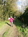
My First Geohash

Achievements