Difference between revisions of "2019-07-22 60 11"
From Geohashing
imported>MaxMad (→Photos) |
imported>MaxMad (→Photos) |
||
| Line 40: | Line 40: | ||
Image:2019-07-22 60 11 1-hydro plant1.jpg | The touristy part | Image:2019-07-22 60 11 1-hydro plant1.jpg | The touristy part | ||
Image:2019-07-22 60 11 2-Entering the woods1.jpg | Less touristy | Image:2019-07-22 60 11 2-Entering the woods1.jpg | Less touristy | ||
| + | Image:2019-07-22 60 11 3-geohash location1.jpg | A fence? Really? | ||
| + | Image:2019-07-22 60 11 4-Screenshot.png | Close enough. | ||
</gallery> | </gallery> | ||
Revision as of 16:14, 22 July 2019
| Mon 22 Jul 2019 in 60,11: 60.0256305, 11.3150553 geohashing.info google osm bing/os kml crox |
Location
In an open field under the power lines close to Rånåsfoss hydro plant. Parking is available at the end of the road near the river.
Participants
Plans
Expedition
Tracklog
Photos
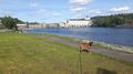
The touristy part
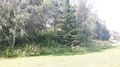
Less touristy
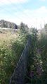
A fence? Really?
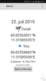
Close enough.


Achievements