Difference between revisions of "2019-07-22 46 -119"
From Geohashing
imported>Thomcat ([live picture]Hop harvest [http://www.openstreetmap.org/?lat=46.25103590&lon=-119.84137480&zoom=16&layers=B000FTF @46.2510,-119.8414]) |
imported>Thomcat (No public access; will finish Teapot Dome (and upload picture which failed to leave the phone) later.) |
||
| Line 1: | Line 1: | ||
| − | |||
| − | |||
| − | |||
| − | |||
| − | |||
| − | |||
| − | |||
| − | |||
| − | |||
| − | |||
{{meetup graticule | {{meetup graticule | ||
| lat=46 | | lat=46 | ||
| lon=-119 | | lon=-119 | ||
| date=2019-07-22 | | date=2019-07-22 | ||
| + | | graticule_name=Tri Cities | ||
| + | | graticule_link=Tri Cities, Washington | ||
}} | }} | ||
| Line 19: | Line 11: | ||
== Location == | == Location == | ||
| − | + | A farmer's field east of Grandview, north of Prosser. | |
== Participants == | == Participants == | ||
| − | + | * [[User:Thomcat|Thomcat]] | |
| − | |||
== Plans == | == Plans == | ||
| Line 29: | Line 20: | ||
== Expedition == | == Expedition == | ||
| − | + | After wrapping up a long weekend, I was headed back to Seattle and this geohash was on the way. Satellite looked like a farmer's field, so not a lot of hope to actually achieve this one. | |
| + | |||
| + | Easily reached a nearby spot on the road and indeed, this is a hop field and they were either tending or harvesting at that moment. I took a few pictures and then headed out. | ||
| + | |||
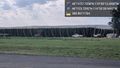
| + | On the way, I stopped at the relocated historical site for [Teapot_Dome_Service_Station]. | ||
== Tracklog == | == Tracklog == | ||
| Line 49: | Line 44: | ||
<!-- Add any achievement ribbons you earned below, or remove this section --> | <!-- Add any achievement ribbons you earned below, or remove this section --> | ||
| − | |||
| − | |||
| − | |||
| − | |||
| − | |||
| − | |||
| − | |||
| − | |||
| − | |||
| − | |||
| − | |||
| − | |||
| − | |||
| − | |||
[[Category:Expeditions]] | [[Category:Expeditions]] | ||
| − | |||
[[Category:Expeditions with photos]] | [[Category:Expeditions with photos]] | ||
| − | |||
| − | |||
| − | |||
| − | |||
| − | |||
| − | |||
| − | |||
| − | |||
| − | |||
[[Category:Coordinates not reached]] | [[Category:Coordinates not reached]] | ||
| − | |||
| − | |||
| − | |||
| − | |||
| − | |||
[[Category:Not reached - No public access]] | [[Category:Not reached - No public access]] | ||
| − | |||
| − | |||
| − | |||
| − | |||
| − | |||
| − | |||
| − | |||
| − | |||
Revision as of 23:40, 23 July 2019
| Mon 22 Jul 2019 in Tri Cities: 46.2493766, -119.8370536 geohashing.info google osm bing/os kml crox |
Location
A farmer's field east of Grandview, north of Prosser.
Participants
Plans
Expedition
After wrapping up a long weekend, I was headed back to Seattle and this geohash was on the way. Satellite looked like a farmer's field, so not a lot of hope to actually achieve this one.
Easily reached a nearby spot on the road and indeed, this is a hop field and they were either tending or harvesting at that moment. I took a few pictures and then headed out.
On the way, I stopped at the relocated historical site for [Teapot_Dome_Service_Station].
Tracklog
Photos
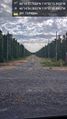
Hops! @46.2484,-119.8418
Hop harvest @46.2510,-119.8414

