Difference between revisions of "2008-06-03 37 -122"
From Geohashing
imported>Mystitat (New page: {{meetup graticule |map=<map lat="37" lon="-122" date="2008-06-03" /> |lat=37 |lon=-122 |date=2008-06-3 }} == Planning == * [http://maps.google.com/?ie=UTF8&q=loc:37.95799267039695,-122....) |
imported>Mystitat |
||
| Line 10: | Line 10: | ||
* [http://maps.google.com/?ie=UTF8&q=loc:37.95799267039695,-122.12893491871844&ll=37.957993,-122.128935&spn=0.002402,0.003964&t=h&z=18&iwloc=addr Google Maps link] | * [http://maps.google.com/?ie=UTF8&q=loc:37.95799267039695,-122.12893491871844&ll=37.957993,-122.128935&spn=0.002402,0.003964&t=h&z=18&iwloc=addr Google Maps link] | ||
*I'm planning to get there around 4:00pm, as per usual xkcd meetup time. Looks like there's easy driving access if you go [http://maps.google.com/maps?f=q&hl=en&geocode=&q=Reliez+Valley+Rd+%4037.964921,+-122.117236&sll=37.926166,-122.069605&sspn=0.009614,0.015857&ie=UTF8&ll=37.965262,-122.117243&spn=0.009609,0.015857&t=h&z=16&iwloc=addr here], then take the little unmarked road to a parking lot within the park. From there, it's a straight walk to the site. (I don't have a gps, so I'm probably going to end up counting the bushes to tell if I'm on the spot.) --[[User:Mystitat|Mystitat]] | *I'm planning to get there around 4:00pm, as per usual xkcd meetup time. Looks like there's easy driving access if you go [http://maps.google.com/maps?f=q&hl=en&geocode=&q=Reliez+Valley+Rd+%4037.964921,+-122.117236&sll=37.926166,-122.069605&sspn=0.009614,0.015857&ie=UTF8&ll=37.965262,-122.117243&spn=0.009609,0.015857&t=h&z=16&iwloc=addr here], then take the little unmarked road to a parking lot within the park. From there, it's a straight walk to the site. (I don't have a gps, so I'm probably going to end up counting the bushes to tell if I'm on the spot.) --[[User:Mystitat|Mystitat]] | ||
| + | |||
| + | == Execution == | ||
| + | |||
| + | *[[User:Mystitat|Mystitat]] arrived around 4:05. There were lots of dog-walkers and cyclists, but no other geohashers. Took some pictures and hung out until about 4:30. | ||
| + | |||
| + | == Photographic Evidence == | ||
| + | <gallery widths="150px" heights="100px" perrow="3"> | ||
| + | Image:2008-06-03-37-122-01.jpg|Warnings were made. | ||
| + | Image:2008-06-03-37-122-06.jpg|Second thoughts were had. | ||
| + | Image:2008-06-03-37-122-02.jpg|The proof! (Well, I don't actually <b>own</b> a gps ... ) | ||
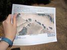
| + | Image:2008-06-03-37-122-05.jpg|Better proof! (You can see on the satellite view that the exact spot is under power lines.) | ||
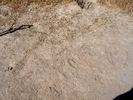
| + | Image:2008-06-03-37-122-03.jpg|If you squint, this pile of stumps/logs nearby kinda looks like like an octopus... | ||
| + | Image:2008-06-03-37-122-04.jpg|Signs were left. | ||
| + | Image:2008-06-03-37-122-07.jpg|Scenery was beautiful. | ||
| + | </gallery> | ||
Revision as of 01:41, 4 June 2008
| Tue 3 Jun 2008 in 37,-122: 37.9579927, -122.1289349 geohashing.info google osm bing/os kml crox |
Planning
- Google Maps link
- I'm planning to get there around 4:00pm, as per usual xkcd meetup time. Looks like there's easy driving access if you go here, then take the little unmarked road to a parking lot within the park. From there, it's a straight walk to the site. (I don't have a gps, so I'm probably going to end up counting the bushes to tell if I'm on the spot.) --Mystitat
Execution
- Mystitat arrived around 4:05. There were lots of dog-walkers and cyclists, but no other geohashers. Took some pictures and hung out until about 4:30.
Photographic Evidence
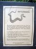
Warnings were made.

Second thoughts were had.
The proof! (Well, I don't actually own a gps ... )
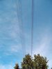
Better proof! (You can see on the satellite view that the exact spot is under power lines.)

If you squint, this pile of stumps/logs nearby kinda looks like like an octopus...
Signs were left.
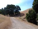
Scenery was beautiful.


