Difference between revisions of "2008-06-06 51 5"
From Geohashing
imported>H.M.Thunder (→Expedition) |
imported>H.M.Thunder (→About) |
||
| Line 2: | Line 2: | ||
The coordinates of this geohash are | The coordinates of this geohash are | ||
<pre> | <pre> | ||
| − | 51.523814°, 5.295407° | + | 51.523814°, 5.295407° [[http://irc.peeron.com/xkcd/map/map.html?date=2008-06-06&lat=51&long=5&zoom=17&abs=1 map]] |
</pre> | </pre> | ||
The hash was north of Oirschot on a field on private property. | The hash was north of Oirschot on a field on private property. | ||
Revision as of 19:11, 6 June 2008
About
The coordinates of this geohash are
51.523814°, 5.295407° [[http://irc.peeron.com/xkcd/map/map.html?date=2008-06-06&lat=51&long=5&zoom=17&abs=1 map]]
The hash was north of Oirschot on a field on private property.
Expedition
H.M.Thunder (Evie and Sjoerd) jumped on their bike when the sun started shining. They stopped at the La Trappe Abbey for a coffee. In Moergestel they were passed by Guus Moonen who is cycling 10.000 km in 20 days around this village. After 90 minutes (23 km) they arrived at 51.523814°, 5.295407°. A nice field with some cows in it. After a pick nick and a photo session they cycled back home. Feeling good after this successful Bicycle_Geohash.
- Pictures
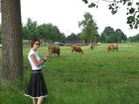
Evie pointing to the third cow who is right at location of the day.
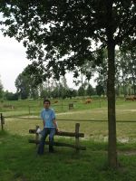
Sjoerd from the opposite direction.
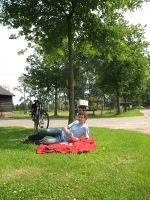
Sjoerd with some bicycle and picknick evidence.


