Difference between revisions of "2008-06-07 34 -117"
imported>Goobergunch (added pictures) |
imported>Goobergunch m |
||
| Line 13: | Line 13: | ||
Image:2008-06-07-34-117-02.jpg | [[User:Goobergunch|Martin]] holding up GPS and paper with coordinates. The actual hash was behind him. | Image:2008-06-07-34-117-02.jpg | [[User:Goobergunch|Martin]] holding up GPS and paper with coordinates. The actual hash was behind him. | ||
Image:2008-06-07-34-117-04.jpg | [[User:Sauron|Chris]] with the same gadgets, in front of one of the many rocks we just didn't feel like climbing anymore. | Image:2008-06-07-34-117-04.jpg | [[User:Sauron|Chris]] with the same gadgets, in front of one of the many rocks we just didn't feel like climbing anymore. | ||
| − | Image:2008-06-07-34-117-05.jpg | Our closest approach. Sadly, we were | + | Image:2008-06-07-34-117-05.jpg | Our closest approach. Sadly, we were 0.83 miles south. |
Image:2008-06-07-34-117-06.jpg | The scenery visible from our closest approach. | Image:2008-06-07-34-117-06.jpg | The scenery visible from our closest approach. | ||
</gallery> | </gallery> | ||
Revision as of 06:05, 8 June 2008
| Sat 7 Jun 2008 in 34,-117: 34.5017842, -117.1143708 geohashing.info google osm bing/os kml crox |
This geohash was in the desert near Apple Valley. Not too far from the road and easy to reach. I got there around 16:00 and wandered around the general area for about 20 minutes. Saw nothing unexpected but it was a nice bit of desert near some hills. Did not come across anybody else. -- far_call
Chris and I got there around 17:30, due to traffic and getting lost. We thought the hash was a bit further south than it was, and attempted to climb the hill between us and the hash. While we didn't end up making to the hash, as climbing without preparation sucks, we do have pictures of our fail. --Martin 05:26, 8 June 2008 (UTC)
- Images from Chris and Martin's failed attempt
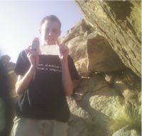
Martin holding up GPS and paper with coordinates. The actual hash was behind him.
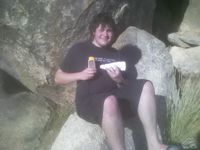
Chris with the same gadgets, in front of one of the many rocks we just didn't feel like climbing anymore.
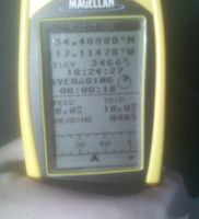
Our closest approach. Sadly, we were 0.83 miles south.
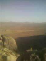
The scenery visible from our closest approach.


