Difference between revisions of "2008-06-07 41 -96"
From Geohashing
imported>AtomicLlama |
imported>Thomcat (Success/failure category added) |
||
| Line 17: | Line 17: | ||
[http://maps.google.com/?ie=UTF8&ll=41.501997,-96.113323&spn=0.004162,0.007585&t=h&z=17&layer=c&cbll=41.500855,-96.113726&panoid=bddnN5Ecg_8b2HXdTksK3g&cbp=1,273.56487434888527,,0,3.075331210197857 Google Street View] of the point | [http://maps.google.com/?ie=UTF8&ll=41.501997,-96.113323&spn=0.004162,0.007585&t=h&z=17&layer=c&cbll=41.500855,-96.113726&panoid=bddnN5Ecg_8b2HXdTksK3g&cbp=1,273.56487434888527,,0,3.075331210197857 Google Street View] of the point | ||
| + | |||
| + | [[Category:Expeditions]] | ||
| + | [[Category:Expeditions with photos]] | ||
| + | [[Category:Coordinates not reached]] | ||
| + | [[Category:Failed - No public access]] | ||
Revision as of 17:48, 7 August 2008
| Sat 7 Jun 2008 in 41,-96: 41.5017842, -96.1143708 geohashing.info google osm bing/os kml crox |
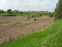
The point was in a fenced field just off of County Road P35 northwest of Fort Calhoun.
Expeditions
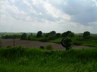
- Matt and Kate arrived right at 4:00pm. Had to drive by and turn around to find a place to park the car. The closest I could get to the point was about 30 feet away, outside the fence. Took a couple of pictures and left within 5 minutes because I had to park closer to the road than I would have liked. The scenery on the drive to the point was excellent for eastern Nebraska.
Pictures
Google Street View of the point

