Difference between revisions of "2019-10-04 48 11"
From Geohashing
Clearlucid9 (talk | contribs) (→Photos) |
Clearlucid9 (talk | contribs) |
||
| Line 13: | Line 13: | ||
2019-10-04 15.55.27.jpg| me in the rain | 2019-10-04 15.55.27.jpg| me in the rain | ||
2019-10-04 15.55.01.jpg| logproof | 2019-10-04 15.55.01.jpg| logproof | ||
| + | 2019-10-04 16.08.21.jpg| all roads closed | ||
</gallery> | </gallery> | ||
Revision as of 20:35, 20 February 2020
Contents
Location
In a forest south of Grasbrunn, south-east of Munich
Participants
~~
Expedition
All roads leading to the cache had been closed for some reason, and so it's been hard to even get close to the hash. After I found one tiny road that led towards the coordinates I had to park the car and walk about 1 km. This area of the forest is used by loggers to store the trunks in large quantities. It's also been raining a bit. I am logging this adventure a couple of months later as this was the first time I realised that the app has stopped working (and the website had gone offline because of the hack. Happy to see that things are back online now (2020-02-20).
Photos
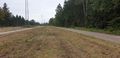
looking north
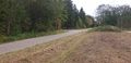
looking south

me in the rain
logproof
all roads closed


