Difference between revisions of "2020-04-20 38 -77"
From Geohashing
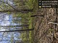
([live picture]It turns out that the geohash point is very close to the summit of this hill here. And boy what a climb! [https://openstreetmap.org/?lat=38.91546730&lon=-77.98139590&zoom=16&layers=B000FTF @38.9155,-77.9814]) |
([live picture]Made it! [https://openstreetmap.org/?lat=38.91519670&lon=-77.98094360&zoom=16&layers=B000FTF @38.9152,-77.9809]) |
||
| Line 42: | Line 42: | ||
Image:2020-04-20_38_-77_OfficeLinebacker_1587413441213.jpg|It turns out that the geohash point is very close to the summit of this hill here. And boy what a climb! [https://openstreetmap.org/?lat=38.91546730&lon=-77.98139590&zoom=16&layers=B000FTF @38.9155,-77.9814] | Image:2020-04-20_38_-77_OfficeLinebacker_1587413441213.jpg|It turns out that the geohash point is very close to the summit of this hill here. And boy what a climb! [https://openstreetmap.org/?lat=38.91546730&lon=-77.98139590&zoom=16&layers=B000FTF @38.9155,-77.9814] | ||
| + | |||
| + | Image:2020-04-20_38_-77_OfficeLinebacker_1587413768801.jpg|Made it! [https://openstreetmap.org/?lat=38.91519670&lon=-77.98094360&zoom=16&layers=B000FTF @38.9152,-77.9809] | ||
</gallery> | </gallery> | ||
Revision as of 20:16, 20 April 2020
| Mon 20 Apr 2020 in 38,-77: 38.9152112, -77.9810824 geohashing.info google osm bing/os kml crox |
Location
Participants
Plans
Expedition
- I'm going for this one, and the next one over if I have time before sunset in e
-- OfficeLinebacker (talk) @39.0112,-77.1506 14:53, 20 April 2020 (EDT)
Tracklog
Photos
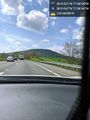
I just pulled over on the side of the highway and I'm going to hike about half a mile into the forest that looks like this @38.9102,-77.9798
It turns out that the geohash point is very close to the summit of this hill here. And boy what a climb! @38.9155,-77.9814

Made it! @38.9152,-77.9809


Achievements