Difference between revisions of "2020-04-29 60 27"
From Geohashing
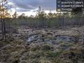
([live picture]At the spot! Dry-ish swamp, but careful navigation required! [https://openstreetmap.org/?lat=60.66355620&lon=27.55868980&zoom=16&layers=B000FTF @60.6636,27.5587]) |
([live picture]Happy to have found a path that makes the hill way easier to cross on the way back. [https://openstreetmap.org/?lat=60.66255690&lon=27.55866660&zoom=16&layers=B000FTF @60.6626,27.5587]) |
||
| Line 38: | Line 38: | ||
Image:2020-04-29_60_27_Artanicus_1588181753345.jpg|At the spot! Dry-ish swamp, but careful navigation required! [https://openstreetmap.org/?lat=60.66355620&lon=27.55868980&zoom=16&layers=B000FTF @60.6636,27.5587] | Image:2020-04-29_60_27_Artanicus_1588181753345.jpg|At the spot! Dry-ish swamp, but careful navigation required! [https://openstreetmap.org/?lat=60.66355620&lon=27.55868980&zoom=16&layers=B000FTF @60.6636,27.5587] | ||
| + | |||
| + | Image:2020-04-29_60_27_Artanicus_1588182259695.jpg|Happy to have found a path that makes the hill way easier to cross on the way back. [https://openstreetmap.org/?lat=60.66255690&lon=27.55866660&zoom=16&layers=B000FTF @60.6626,27.5587] | ||
</gallery> | </gallery> | ||
Revision as of 17:44, 29 April 2020
| Wed 29 Apr 2020 in 60,27: 60.6635212, 27.5585581 geohashing.info google osm bing/os kml crox |
Location
Participants
Plans
Expedition
Tracklog
Photos
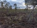
Forest turns to swamp, is this the end of the attempt? @60.6628,27.5585
At the spot! Dry-ish swamp, but careful navigation required! @60.6636,27.5587
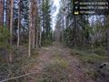
Happy to have found a path that makes the hill way easier to cross on the way back. @60.6626,27.5587


Achievements