Difference between revisions of "2020-05-03 -37 144"
Felix Dance (talk | contribs) ([live picture]Sort of success!) |
Felix Dance (talk | contribs) (Added expedition) |
||
| Line 1: | Line 1: | ||
| − | + | [[Image:{{{2020-05-03_-37_144_Felix Dance_1588485667420.jpg|GPS view}}}|thumb|left]] | |
| − | + | {{meetup graticule | |
| − | |||
| − | |||
| − | |||
| − | |||
| − | |||
| − | |||
| lat=-37 | | lat=-37 | ||
| lon=144 | | lon=144 | ||
| date=2020-05-03 | | date=2020-05-03 | ||
| − | }} | + | }} |
__NOTOC__ | __NOTOC__ | ||
| + | |||
== Location == | == Location == | ||
| − | + | Just inside the front of a house in Coburg. | |
== Participants == | == Participants == | ||
| − | + | *[[User:Felix Dance|Felix Dance]] | |
| − | + | *[[User:Stevage|Stevage]] | |
| + | *Ruth | ||
| − | == | + | == Expedition == |
| − | + | I found this geohash the day before, which was convenient because it was on a weekend day and I was looking for a nice bike path ride for Sunday. | |
| − | + | The day having arrived, Ruth and I got on our bike and headed along the Capital City Trail, up Moonee Ponds Creek, then onto the Merri Creek Bike Path. There we met Stevage and all three of us avoided the packed bike path due to Corona-related exercising to get up to the hash. | |
| − | + | ||
| + | Soon we departed the creek and headed through the tall, stone walls of the urban-renewed Pentridge Prison. Within a few minutes we'd arrived at the street of the hash. | ||
| + | |||
| + | Unfortunately, the hash was just inside someone's house - right at the front. They had a locked gate at the entrance which foiled my plan of getting close enough by just walking into their driveway a bit. By climbing on the fence and holding my arm out the closest I could get my phone to hash was 5.3m. Since I somewhat arbitrarily feel like 5m proximity counts as success I don't think we can really claim this one. | ||
| + | |||
| + | Ruth then went home along Sydney Rd, the direct route, while Stevage and I headed to our friends Mitch and Cat's place to see them at a distance. From there Stevage and I rode home along Moonee Ponds Creek bike path, taking the more adventurous, single-tracky left bank for some of the way. | ||
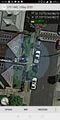
| − | + | Sadly, I forgot to take any photos of the hash, with only my GPS proof as a remnant of our activities. | |
| − | |||
== Photos == | == Photos == | ||
| − | |||
| − | |||
| − | |||
<gallery perrow="5"> | <gallery perrow="5"> | ||
| Line 40: | Line 37: | ||
== Achievements == | == Achievements == | ||
{{#vardefine:ribbonwidth|800px}} | {{#vardefine:ribbonwidth|800px}} | ||
| − | + | {{bicycle geohash | |
| + | |||
| + | | latitude = -37 | ||
| + | | longitude = 144 | ||
| + | | date = 2020-05-03 | ||
| + | | name = Felix, Stevage and Ruth | ||
| + | | distance = 32.3 kms | ||
| + | | bothways = true | ||
| + | | image = | ||
| + | }} | ||
| − | |||
| − | |||
[[Category:New report]] | [[Category:New report]] | ||
| − | |||
| − | |||
| − | |||
| − | |||
| − | |||
| − | |||
| − | |||
| − | |||
| − | |||
| − | |||
| − | |||
[[Category:Expeditions]] | [[Category:Expeditions]] | ||
| − | |||
[[Category:Expeditions with photos]] | [[Category:Expeditions with photos]] | ||
| − | |||
| − | |||
| − | |||
| − | |||
| − | |||
| − | |||
| − | |||
| − | |||
| − | |||
[[Category:Coordinates not reached]] | [[Category:Coordinates not reached]] | ||
| − | |||
| − | |||
| − | |||
| − | |||
| − | |||
[[Category:Not reached - No public access]] | [[Category:Not reached - No public access]] | ||
| − | |||
| − | |||
| − | |||
| − | |||
| − | |||
| − | |||
| − | |||
| − | |||
Revision as of 02:45, 4 May 2020
| Sun 3 May 2020 in -37,144: -37.7366214, 144.9615949 geohashing.info google osm bing/os kml crox |
Location
Just inside the front of a house in Coburg.
Participants
- Felix Dance
- Stevage
- Ruth
Expedition
I found this geohash the day before, which was convenient because it was on a weekend day and I was looking for a nice bike path ride for Sunday.
The day having arrived, Ruth and I got on our bike and headed along the Capital City Trail, up Moonee Ponds Creek, then onto the Merri Creek Bike Path. There we met Stevage and all three of us avoided the packed bike path due to Corona-related exercising to get up to the hash.
Soon we departed the creek and headed through the tall, stone walls of the urban-renewed Pentridge Prison. Within a few minutes we'd arrived at the street of the hash.
Unfortunately, the hash was just inside someone's house - right at the front. They had a locked gate at the entrance which foiled my plan of getting close enough by just walking into their driveway a bit. By climbing on the fence and holding my arm out the closest I could get my phone to hash was 5.3m. Since I somewhat arbitrarily feel like 5m proximity counts as success I don't think we can really claim this one.
Ruth then went home along Sydney Rd, the direct route, while Stevage and I headed to our friends Mitch and Cat's place to see them at a distance. From there Stevage and I rode home along Moonee Ponds Creek bike path, taking the more adventurous, single-tracky left bank for some of the way.
Sadly, I forgot to take any photos of the hash, with only my GPS proof as a remnant of our activities.
Photos
Sort of success!

Achievements
Felix, Stevage and Ruth earned the Bicycle geohash achievement
|