Difference between revisions of "2020-05-10 39 -77"
From Geohashing
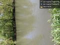
([live picture]The map vastly overstates the amount of land between the road and the river. It's really about 20 feet if that. [https://openstreetmap.org/?lat=39.71347140&lon=-77.82983170&zoom=16&layers=B000FTF @39.7135,-77.8298]) |
([live picture]I'm calling it a make. [https://openstreetmap.org/?lat=39.71346370&lon=-77.82985100&zoom=16&layers=B000FTF @39.7135,-77.8299]) |
||
| Line 38: | Line 38: | ||
Image:2020-05-10_39_-77_OfficeLinebacker_1589133482898.jpg|The map vastly overstates the amount of land between the road and the river. It's really about 20 feet if that. [https://openstreetmap.org/?lat=39.71347140&lon=-77.82983170&zoom=16&layers=B000FTF @39.7135,-77.8298] | Image:2020-05-10_39_-77_OfficeLinebacker_1589133482898.jpg|The map vastly overstates the amount of land between the road and the river. It's really about 20 feet if that. [https://openstreetmap.org/?lat=39.71347140&lon=-77.82983170&zoom=16&layers=B000FTF @39.7135,-77.8298] | ||
| + | |||
| + | Image:2020-05-10_39_-77_OfficeLinebacker_1589133544558.jpg|I'm calling it a make. [https://openstreetmap.org/?lat=39.71346370&lon=-77.82985100&zoom=16&layers=B000FTF @39.7135,-77.8299] | ||
</gallery> | </gallery> | ||
Revision as of 17:59, 10 May 2020
| Sun 10 May 2020 in 39,-77: 39.7133386, -77.8297909 geohashing.info google osm bing/os kml crox |
Location
Participants
Plans
Expedition
- P I'm going for this one as well, but I don't have much hope that I can get close because -- OfficeLinebacker (talk) @39.6944,-78.6475 13:01, 10 May 2020 (EDT)
Tracklog
Photos

The map vastly overstates the amount of land between the road and the river. It's really about 20 feet if that. @39.7135,-77.8298
I'm calling it a make. @39.7135,-77.8299


Achievements