Difference between revisions of "2020-06-16 39 -77"
From Geohashing
([live picture]Here we go. [https://openstreetmap.org/?lat=39.07242830&lon=-77.91172740&zoom=16&layers=B000FTF @39.0724,-77.9117]) |
([live] Met Jessica at the waterfall. Onward.) |
||
| Line 30: | Line 30: | ||
*I had to park here, two and a half miles away, to gain the access I needed. -- [[User:OfficeLinebacker|OfficeLinebacker]] ([[User talk:OfficeLinebacker|talk]]) [https://openstreetmap.org/?lat=39.07282060&lon=-77.91267700&zoom=16&layers=B000FTF @39.0728,-77.9127] 17:37, 16 June 2020 (EDT) | *I had to park here, two and a half miles away, to gain the access I needed. -- [[User:OfficeLinebacker|OfficeLinebacker]] ([[User talk:OfficeLinebacker|talk]]) [https://openstreetmap.org/?lat=39.07282060&lon=-77.91267700&zoom=16&layers=B000FTF @39.0728,-77.9127] 17:37, 16 June 2020 (EDT) | ||
| + | |||
| + | *Met Jessica at the waterfall. Onward. -- [[User:OfficeLinebacker|OfficeLinebacker]] ([[User talk:OfficeLinebacker|talk]]) [https://openstreetmap.org/?lat=39.06954020&lon=-77.90259100&zoom=16&layers=B000FTF @39.0695,-77.9026] 18:12, 16 June 2020 (EDT) | ||
== Tracklog == | == Tracklog == | ||
<!-- if your GPS device keeps a log, you may post a link here --> | <!-- if your GPS device keeps a log, you may post a link here --> | ||
Revision as of 22:12, 16 June 2020
| Tue 16 Jun 2020 in 39,-77: 39.0964922, -77.8818796 geohashing.info google osm bing/os kml crox |
Location
Participants
Plans
Expedition
- So this one is going to be very complicated because it's right next to the Appalachian trail but there's a lot of private property to the Appalachian trail so access is complicated -- OfficeLinebacker (talk) @39.0991,-77.9020 17:28, 16 June 2020 (EDT)
- I had to park here, two and a half miles away, to gain the access I needed. -- OfficeLinebacker (talk) @39.0728,-77.9127 17:37, 16 June 2020 (EDT)
- Met Jessica at the waterfall. Onward. -- OfficeLinebacker (talk) @39.0695,-77.9026 18:12, 16 June 2020 (EDT)
Tracklog
Photos
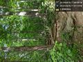
Here we go. @39.0724,-77.9117

Achievements