Difference between revisions of "2020-06-16 39 -77"
From Geohashing
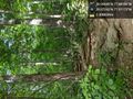
([live picture]unfortunately, this is where the journey ends. The Appalachian trail takes an extremely winding route, and while the distance as the crow flies was 2.5 miles, the distance hiked up until now is over four miles of very steep and sometimes...) |
([live] I simply ran out of time, and my turnaround alarms sounded. Even after pressing on for a while after that) |
||
| Line 32: | Line 32: | ||
*Met Jessica at the waterfall. Onward. -- [[User:OfficeLinebacker|OfficeLinebacker]] ([[User talk:OfficeLinebacker|talk]]) [https://openstreetmap.org/?lat=39.06954020&lon=-77.90259100&zoom=16&layers=B000FTF @39.0695,-77.9026] 18:12, 16 June 2020 (EDT) | *Met Jessica at the waterfall. Onward. -- [[User:OfficeLinebacker|OfficeLinebacker]] ([[User talk:OfficeLinebacker|talk]]) [https://openstreetmap.org/?lat=39.06954020&lon=-77.90259100&zoom=16&layers=B000FTF @39.0695,-77.9026] 18:12, 16 June 2020 (EDT) | ||
| + | |||
| + | *I simply ran out of time, and my turnaround alarms sounded. Even after pressing on for a while after that -- [[User:OfficeLinebacker|OfficeLinebacker]] ([[User talk:OfficeLinebacker|talk]]) [https://openstreetmap.org/?lat=39.09167340&lon=-77.88668950&zoom=16&layers=B000FTF @39.0917,-77.8867] 19:47, 16 June 2020 (EDT) | ||
== Tracklog == | == Tracklog == | ||
<!-- if your GPS device keeps a log, you may post a link here --> | <!-- if your GPS device keeps a log, you may post a link here --> | ||
Revision as of 23:47, 16 June 2020
| Tue 16 Jun 2020 in 39,-77: 39.0964922, -77.8818796 geohashing.info google osm bing/os kml crox |
Location
Participants
Plans
Expedition
- So this one is going to be very complicated because it's right next to the Appalachian trail but there's a lot of private property to the Appalachian trail so access is complicated -- OfficeLinebacker (talk) @39.0991,-77.9020 17:28, 16 June 2020 (EDT)
- I had to park here, two and a half miles away, to gain the access I needed. -- OfficeLinebacker (talk) @39.0728,-77.9127 17:37, 16 June 2020 (EDT)
- Met Jessica at the waterfall. Onward. -- OfficeLinebacker (talk) @39.0695,-77.9026 18:12, 16 June 2020 (EDT)
- I simply ran out of time, and my turnaround alarms sounded. Even after pressing on for a while after that -- OfficeLinebacker (talk) @39.0917,-77.8867 19:47, 16 June 2020 (EDT)
Tracklog
Photos
Here we go. @39.0724,-77.9117

unfortunately, this is where the journey ends. The Appalachian trail takes an extremely winding route, and while the distance as the crow flies was 2.5 miles, the distance hiked up until now is over four miles of very steep and sometimes rugged trail @39.0918,-77.8867


Achievements