Difference between revisions of "2020-08-24 48 11"
Clearlucid9 (talk | contribs) (→Expedition) |
Clearlucid9 (talk | contribs) (→Photos) |
||
| Line 41: | Line 41: | ||
Image:2020-08-24_48_11_Clearlucid9 _1598283484435.jpg|Standing at the hash | Image:2020-08-24_48_11_Clearlucid9 _1598283484435.jpg|Standing at the hash | ||
| − | Image:2020-08-24_48_11_Clearlucid9 | + | Image:2020-08-24_48_11_Clearlucid9 _1598284777034.jpg|Nature'sLogbook |
| − | Image:2020-08-24_48_11_Clearlucid9 | + | Image:2020-08-24_48_11_Clearlucid9 _1598283511528.jpg| first ever (?) signed Geohashing logbook |
Image:2020-08-24_48_11_Clearlucid9 _1598284809847.jpg|View from hashpoint | Image:2020-08-24_48_11_Clearlucid9 _1598284809847.jpg|View from hashpoint | ||
Revision as of 20:21, 26 August 2020
| Mon 24 Aug 2020 in 48,11: 48.0340621, 11.7758476 geohashing.info google osm bing/os kml crox |
Location
In a forest between Putzbrunn and Oberpframmern, south-east of Munich
Participants
Plans
Expedition
I set out to drive to this cache after a day's work in the homeoffice. As too many times Google maps insisted that I would be able to drive over the gravel roads in the forest, but as most of the time in Germany this is forbidden. As a consequence I had to walk about 1 km from my parking spot. But a bit of activity at the fresh air never does any harm, doesn't it? After a while I reached the coordinates, took my pictures and then when I looked at the ground I saw a piece of birch tree bark that resembled a geocaching logbook. I couldn't resist and had to sign this nature given logbook ;-) After carefully placing this first ever (?) Geohashing logbook on a tree stump I walked back to my car and returned home.
Tracklog
Photos

Logproof

Standing at the hash

Nature'sLogbook
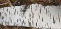
first ever (?) signed Geohashing logbook
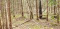
View from hashpoint
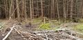
Looking in the opposite direction
Achievements