Difference between revisions of "Rockall, Atlantic Ocean"
From Geohashing
GoodClover (talk | contribs) (Info about Rockall) |
GoodClover (talk | contribs) (Image) |
||
| Line 1: | Line 1: | ||
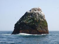
| + | [[File:Rockall.jpg|thumb|right|200px]] | ||
| + | |||
{{graticule | {{graticule | ||
| lat= 57 | | lat= 57 | ||
| Line 12: | Line 14: | ||
| se = [[56,-12]] | | se = [[56,-12]] | ||
}} | }} | ||
| + | |||
This graticule is located at [[57,-13]]. [http://carabiner.peeron.com/xkcd/map/map.html?lat=57&long=-13&zoom=9&abs=-1 Today's location] | This graticule is located at [[57,-13]]. [http://carabiner.peeron.com/xkcd/map/map.html?lat=57&long=-13&zoom=9&abs=-1 Today's location] | ||
Revision as of 15:33, 16 June 2021
| 58,-14 | 58,-13 | 58,-12 |
| 57,-14 | Rockall | 57,-12 |
| 56,-14 | 56,-13 | 56,-12 |
|
Today's location: geohashing.info google osm bing/os kml crox | ||
This graticule is located at 57,-13. Today's location
It is theoretically possible to get a land geohash on top of Rockall, however the chances of this are extremely unlikely. And being able to travel to Rockall is probably even less likely.
If you zoom to the centre of the circle on the map to the right, Rockall will eventually show up. Or you can just see it on OSM.
