Difference between revisions of "2021-08-19 52 16"
(Created page with "{{meetup graticule | lat=52 | lon=16 | date=2021-08-19 }} == Location == In the Puszcza Notecka, near Obrzycko. == Participants == amn == Plans == [https:/...") |
(→Photos) |
||
| Line 38: | Line 38: | ||
Image:IMG_4439.jpg | Come on Adi boy! You're nearly there! | Image:IMG_4439.jpg | Come on Adi boy! You're nearly there! | ||
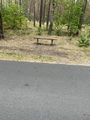
Image:IMG_4440.jpg | Last bench on the way to destination | Image:IMG_4440.jpg | Last bench on the way to destination | ||
| − | |||
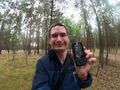
Image:GPTempDownload.jpg | Me at the geohash - wide lens | Image:GPTempDownload.jpg | Me at the geohash - wide lens | ||
Image:IMG_4442.jpg | Me at the geohash | Image:IMG_4442.jpg | Me at the geohash | ||
Revision as of 16:50, 22 August 2021
| Thu 19 Aug 2021 in 52,16: 52.7180261, 16.4970542 geohashing.info google osm bing/os kml crox |
Contents
[hide]Location
In the Puszcza Notecka, near Obrzycko.
Participants
Plans
This post on Hacker News reminded me of Geohashing. I checked that nobody was in Poznań's graticule coordinates, so I intended to seize the opportunity. The trip was pretty spontaneous. I intended to travel to Pęckowo by train and then go by foot 8 km to destination.
Expedition
I went by train to Pęckowo, then went by foot to destination.
In Obrzycko I found building which looked like a train station. I was wandering if it was actually active (it wasn't on map), because that would mean that I needn't walk last 5 km. I came nearly and chatted with local, who seems to live there. Turns out it was a train station but about 22 years ago.
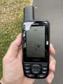
I've stopped when GPS announced that I've arrived at destination (I was within 3 meters from destination), took photos, left memorial poster (created manually) on nearest tree, and went back.
Tracklog
Photos
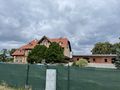
Old train station in Obrzycko
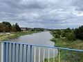
Warta
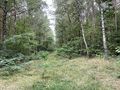
Puszcza Notecka
Come on Adi boy! You're nearly there!
Last bench on the way to destination
Me at the geohash - wide lens

Me at the geohash

Me with poorly attached poster. If you want my autograph, you know where to find it

Me waiting for the return train


