Difference between revisions of "2021-11-10 55 37"
From Geohashing
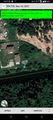
([live picture]At the hash [https://openstreetmap.org/?mlat=55.51568056&mlon=37.39114444&zoom=16 @55.5157,37.3911]) |
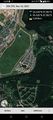
([live picture]Desna river near the hash [https://openstreetmap.org/?mlat=55.51567778&mlon=37.39116389&zoom=16 @55.5157,37.3912]) |
||
| Line 40: | Line 40: | ||
Image:2021-11-10_55_37_vb_1636543894772.jpg|At the hash [https://openstreetmap.org/?mlat=55.51568056&mlon=37.39114444&zoom=16 @55.5157,37.3911] | Image:2021-11-10_55_37_vb_1636543894772.jpg|At the hash [https://openstreetmap.org/?mlat=55.51568056&mlon=37.39114444&zoom=16 @55.5157,37.3911] | ||
| + | |||
| + | Image:2021-11-10_55_37_vb_1636543939796.jpg|Desna river near the hash [https://openstreetmap.org/?mlat=55.51567778&mlon=37.39116389&zoom=16 @55.5157,37.3912] | ||
</gallery> | </gallery> | ||
Revision as of 11:32, 10 November 2021
| Wed 10 Nov 2021 in 55,37: 55.5157004, 37.3911342 geohashing.info google osm bing/os kml crox |
Location
Participants
Plans
Expedition
Tracklog
Photos
Coordinates reached
On the bank of Desna river just outside of "Anderssen" neighbourhood of New Moscow.
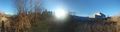
At the hash @55.5157,37.3911
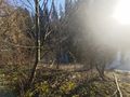
Desna river near the hash @55.5157,37.3912


Achievements