Difference between revisions of "2008-07-12 51 4"
From Geohashing
imported>Madjo |
imported>Thomcat (Success/failure category added) |
||
| Line 18: | Line 18: | ||
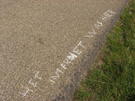
[http://www.flickr.com/photos/madjo/2661702265/in/set-72157606127581350/ [[image:51_4_12-07_het_internet_was_hier.jpg]]] | [http://www.flickr.com/photos/madjo/2661702265/in/set-72157606127581350/ [[image:51_4_12-07_het_internet_was_hier.jpg]]] | ||
| + | |||
| + | [[Category:Expeditions]] | ||
| + | [[Category:Expeditions with photos]] | ||
| + | [[Category:Coordinates not reached]] | ||
| + | [[Category:Failed - No public access]] | ||
Revision as of 04:50, 12 August 2008
| Sat 12 Jul 2008 in 51,4: 51.6128965, 4.2604917 geohashing.info google osm bing/os kml crox |
The location of July 12th, 2008 was near De Heen, a small village near the (not so big) town called Steenbergen in Noord-Brabant.
I, (MadJo) went there, as a spur of the moment thing. I didn't have anything better to do. So I off I went, armed with my TomTom and my digital camera. Not really sure what to expect.
I did not reach the exact position; the farmland it was in, was not accessible from my side of the field.
But I got really close, and left a mark on the side of the road.
Sadly no one else arrived, unless that group of walkers I spotted in the distance as I was leaving the area were also from The Internet.
Photos can be found here on my Flickr page.

