Difference between revisions of "2022-02-24 40 -74"
From Geohashing
(Created page with " {{subst:Expedition}}") |
(Created successful expedition page) |
||
| Line 1: | Line 1: | ||
| − | + | <!-- If you did not specify these parameters in the template, please substitute appropriate values for IMAGE, LAT, LON, and DATE (YYYY-MM-DD format) | |
[[Image:{{{image|IMAGE}}}|thumb|left]] | [[Image:{{{image|IMAGE}}}|thumb|left]] | ||
| Line 15: | Line 15: | ||
== Location == | == Location == | ||
<!-- where you've surveyed the hash to be --> | <!-- where you've surveyed the hash to be --> | ||
| + | The north bit of South Mountain reservation, about 500 ft from a dead end road | ||
== Participants == | == Participants == | ||
<!-- who attended: If you link to your wiki user name in this section, your expedition will be picked up by the various statistics generated for geohashing. You may use three tildes ~ as a shortcut to automatically insert the user signature of the account you are editing with. | <!-- who attended: If you link to your wiki user name in this section, your expedition will be picked up by the various statistics generated for geohashing. You may use three tildes ~ as a shortcut to automatically insert the user signature of the account you are editing with. | ||
| − | --> | + | --> |
| + | [[User:Signore Galilei|Signore Galilei]] ([[User talk:Signore Galilei|talk]]) | ||
== Plans == | == Plans == | ||
<!-- what were the original plans --> | <!-- what were the original plans --> | ||
| + | Drive to the end of the dead end and walk the 500 ft to the hash site. | ||
== Expedition == | == Expedition == | ||
<!-- how it all turned out. your narrative goes here. --> | <!-- how it all turned out. your narrative goes here. --> | ||
| + | All worked out very nicely. There was a trail in the woods that we followed for a little before turning off to the hash point. | ||
== Tracklog == | == Tracklog == | ||
| Line 34: | Line 38: | ||
--> | --> | ||
<gallery perrow="5"> | <gallery perrow="5"> | ||
| + | Image:SG&Dad_2022-02-24.jpg | Signore Galilei and Dad | ||
| + | Image:Screenshot_20220224-123800.png | My Geohashing App | ||
</gallery> | </gallery> | ||
Revision as of 03:05, 26 February 2022
| Thu 24 Feb 2022 in 40,-74: 40.7809136, -74.2866132 geohashing.info google osm bing/os kml crox |
Location
The north bit of South Mountain reservation, about 500 ft from a dead end road
Participants
Plans
Drive to the end of the dead end and walk the 500 ft to the hash site.
Expedition
All worked out very nicely. There was a trail in the woods that we followed for a little before turning off to the hash point.
Tracklog
Photos
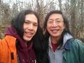
Signore Galilei and Dad
My Geohashing App


Achievements