Difference between revisions of "2022-02-27 50 11"
From Geohashing
ScepticAnna (talk | contribs) |
ScepticAnna (talk | contribs) (→Photos) |
||
| Line 37: | Line 37: | ||
--> | --> | ||
<gallery perrow="5"> | <gallery perrow="5"> | ||
| + | Image:2022-02-27_50_11_Anna_approach_rs.JPG | Approach to the point | ||
| + | Image:2022-02-27_50_11_Anna_mud_rs.JPG | Which is worse: frozen or liquid mud? | ||
| + | Image:2022-02-27_50_11_Anna_proof_rs.JPG | Proof, or close enough | ||
| + | Image:2022-02-27_50_11_Anna_point_rs.JPG | View from the point | ||
| + | Image:2022-02-27_50_11_Anna_icestream_rs.JPG | Stream still half frozen over after noon | ||
</gallery> | </gallery> | ||
Revision as of 17:48, 27 February 2022
| Sun 27 Feb 2022 in 50,11: 50.9300790, 11.3497674 geohashing.info google osm bing/os kml crox |
Location
In a field near Oettern. Looks like it's close to a path, so it should be reachable.
Participants
Plans
I'm planning to go there by bike from Jena, start time depends on the temperature. Anna
Expedition
Tracklog
Photos
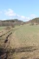
Approach to the point
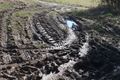
Which is worse: frozen or liquid mud?
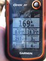
Proof, or close enough
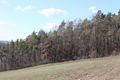
View from the point
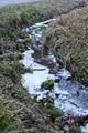
Stream still half frozen over after noon


