Difference between revisions of "2023-05-01 -37 144"
(→Location) |
|||
| Line 1: | Line 1: | ||
| − | |||
| − | |||
| − | + | [[Image:{{{image|2023-05-01_-37_144_Johnwrw_1682992350942.jpg}}}|thumb|left]] | |
| − | |||
| − | + | {{meetup graticule | |
| − | |||
| lat=-37 | | lat=-37 | ||
| lon=144 | | lon=144 | ||
| date=2023-05-01 | | date=2023-05-01 | ||
| − | }} | + | }} |
== Location == | == Location == | ||
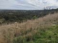
At the Vasa Place reserve, in a suburb I'd never heard of before, Keilor Lodge | At the Vasa Place reserve, in a suburb I'd never heard of before, Keilor Lodge | ||
== Participants == | == Participants == | ||
| − | + | ||
| − | + | *[[User:Johnwrw|John]] | |
| − | *[[User:Johnwrw| | ||
== Plans == | == Plans == | ||
| − | + | After improving my longest geohash on foot from 15km to 23km with my trip to Williamstown in February, and with my running fitness in a good place at the moment, I’ve been keen for some time to see how much further I could push up the leaderboard. | |
| + | On Friday night at 11:30 when the upcoming three days’ hashes were released, I was immediately drawn to Monday’s as an option for a running expedition. I could follow a nice 20ish kilometre long route along the Maribyrnong River for much of the way, and with trains not too far away I could bail out at some point along the way home if I wasn’t feeling like completing a full 40km trek. | ||
| + | As the weekend wore on, I became more firm in my conviction to mount this expedition. But a spanner had been introduced. On Sunday morning, Bridget decided that she was heading off to get a flu shot and another covid jab, and she strongly encouraged me to get the flu shot too. (My last covid vax had been too recent for me to get another one of those yet). I decided that I would get it, but it was going to be a roll of the dice as to whether I would be up for a long run the next day, with my immune system having been worked up by a foreign substance having been injected into my arm. | ||
| + | As the day and evening progressed, I was feeling fine but unusually tired. We had an excellent dinner of homemade pizzas, but I was almost falling asleep standing up at the sink doing the dishes afterwards. Nothing a good night’s sleep couldn’t fix though. | ||
| + | I ploughed on in my planning for the morning, and I realised that one of the default routes that Google maps had suggested, which I had initially dismissed as mostly uninteresting roads, was in fact much more intriguing. It wasn’t too far off a straight line at all. A juggernaut achievement was well and truly on here. | ||
| + | Taking additional inspiration from the youtuber Geowizard, whose straight-line missions I had watched a lot of in recent months, I knew I had to go for it. While I would be far from meeting the straightness constraints that he imposes (ideally no more than 25m off the perfect straight line), it would be eminently doable to meet the juggernaut achievement regulation as listed on the wiki, of deviating by no more than 5% of the length of the straight line. | ||
| + | The straight line between home and the hash was 14.38km long, so I could deviate by up to a generous 719m. I could see from the map that the biggest deviation was going to be incurred in Keilor East while crossing the Melbourne to Sydney trainline, and the Ring Road. There was definitely no better option than following Keilor Park Drive around to the south of my straight line. However, I estimated that this would only take me 500m or so off the line. The rest of the trip would involve nothing like that much of a deviation. | ||
| + | It also occurred to me that if I then took the longer way home along the river that I could do a Tron achievement as well, which I was yet to succeed in, despite attempting it first 9 years ago. (Not that there had been many intervening attempts). | ||
| + | |||
== Expedition == | == Expedition == | ||
Revision as of 12:47, 11 May 2023

| Mon 1 May 2023 in -37,144: -37.6960156, 144.7992520 geohashing.info google osm bing/os kml crox |
Location
At the Vasa Place reserve, in a suburb I'd never heard of before, Keilor Lodge
Participants
Plans
After improving my longest geohash on foot from 15km to 23km with my trip to Williamstown in February, and with my running fitness in a good place at the moment, I’ve been keen for some time to see how much further I could push up the leaderboard. On Friday night at 11:30 when the upcoming three days’ hashes were released, I was immediately drawn to Monday’s as an option for a running expedition. I could follow a nice 20ish kilometre long route along the Maribyrnong River for much of the way, and with trains not too far away I could bail out at some point along the way home if I wasn’t feeling like completing a full 40km trek. As the weekend wore on, I became more firm in my conviction to mount this expedition. But a spanner had been introduced. On Sunday morning, Bridget decided that she was heading off to get a flu shot and another covid jab, and she strongly encouraged me to get the flu shot too. (My last covid vax had been too recent for me to get another one of those yet). I decided that I would get it, but it was going to be a roll of the dice as to whether I would be up for a long run the next day, with my immune system having been worked up by a foreign substance having been injected into my arm. As the day and evening progressed, I was feeling fine but unusually tired. We had an excellent dinner of homemade pizzas, but I was almost falling asleep standing up at the sink doing the dishes afterwards. Nothing a good night’s sleep couldn’t fix though. I ploughed on in my planning for the morning, and I realised that one of the default routes that Google maps had suggested, which I had initially dismissed as mostly uninteresting roads, was in fact much more intriguing. It wasn’t too far off a straight line at all. A juggernaut achievement was well and truly on here. Taking additional inspiration from the youtuber Geowizard, whose straight-line missions I had watched a lot of in recent months, I knew I had to go for it. While I would be far from meeting the straightness constraints that he imposes (ideally no more than 25m off the perfect straight line), it would be eminently doable to meet the juggernaut achievement regulation as listed on the wiki, of deviating by no more than 5% of the length of the straight line. The straight line between home and the hash was 14.38km long, so I could deviate by up to a generous 719m. I could see from the map that the biggest deviation was going to be incurred in Keilor East while crossing the Melbourne to Sydney trainline, and the Ring Road. There was definitely no better option than following Keilor Park Drive around to the south of my straight line. However, I estimated that this would only take me 500m or so off the line. The rest of the trip would involve nothing like that much of a deviation. It also occurred to me that if I then took the longer way home along the river that I could do a Tron achievement as well, which I was yet to succeed in, despite attempting it first 9 years ago. (Not that there had been many intervening attempts).
Expedition
Tracklog
I have superimposed the perfectly straight line between home and the hash for juggernaut analysis
Photos
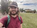
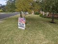
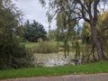
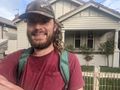
Success

Little creek I juggernauted over
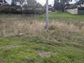
Maribyrnong defence site
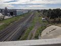
Railway that couldn't be juggernauted over
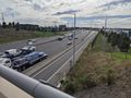
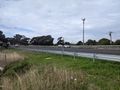
And freeway that couldn't either
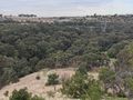
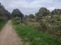
Brimbank Park from the south
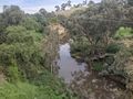
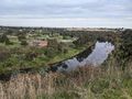
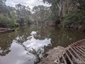
Maribyrnong river at Keilor
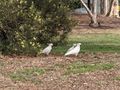
Cockatoos
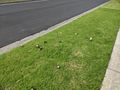
Mushrooms
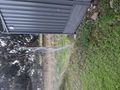
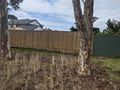
Nice fence gap
Nice open gate on other side
On off ramps I crossed
Maybe i could have gone under
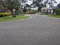
Local concerns
Fence to get over sort of through someone's front yard
And the drop on the other side
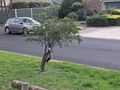
This tree bears strange fruit
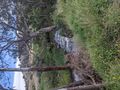
Taylors creek
Brimbank Park again, from the north, e.j. Whitten bridge in the distance
Maribyrnong river ford at Brimbank Park
More scenic river
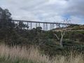
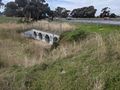
A good viaduct
Pipe bridge ahead
The new house


Achievements