Difference between revisions of "2023-08-14 38 -121"
(→Expedition) |
(→Photos) |
||
| Line 41: | Line 41: | ||
--> | --> | ||
<gallery perrow="5"> | <gallery perrow="5"> | ||
| + | Image:2023-08-14 38 -121 Geohash Droid Screenshot.png | ||
| + | Image:2023-08-14 38 -121 Concrete Pad.jpg | The aerial photography suggests that the actual hash point is at the corner of this concrete pad behind the fence | ||
| + | Image:2023-08-14 38 -121 Selfie.jpg | ||
</gallery> | </gallery> | ||
Revision as of 05:21, 15 August 2023
| Mon 14 Aug 2023 in 38,-121: 38.5652050, -121.5698176 geohashing.info google osm bing/os kml crox |
Location
Participants
Plans
Looks like the actual point is in a restricted area near the Port of Sacramento. Point indicated is close enough to the fence that it is possible that the imagery is not correctly aligned and/or a point reachable outside the fence is within GPS accuracy circle of the calculated point. Might attempt around 18:00. Robartsd (talk)
Expedition
We decided to go for it. Although the point indicated on the the aerial photography on Google Maps was behind a fence, but it was very easy to get within GPS accuracy of the point (and even meters beyond it, so the photography alignment might be off).
Part of our reason for going for it was simply to get out of the house - which only has air conditioning in the bedroom, so we checked out the Goodwill store we had passed on our way to the hash point. We bought a soup mug that matches a set that we have (in the same color as one that we have chipped the lip of), some games, and a Marvel T-shirt.
After Goodwill closed at 8pm, we eat at Oscar's Very Mexican Food. We ordered a Fajitas Burrito and a Chimichanga. The Chimichanga was beautifully plated (the Burrito was wrapped up just like it would be to go). We finished eating as Oscar's closed at 9 pm, then headed home to hide out in the bedroom air conditioning again.
Tracklog
Photos
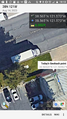
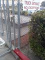
The aerial photography suggests that the actual hash point is at the corner of this concrete pad behind the fence


Achievements