Difference between revisions of "2023-12-17 57 -1"
From Geohashing
Alunhewinson (talk | contribs) (→Photos: uploaded photos from visit) |
Alunhewinson (talk | contribs) (→Photos: make gallery) |
||
| Line 15: | Line 15: | ||
== Photos == | == Photos == | ||
| − | + | <gallery perrow="5"> | |
| − | + | Image:Screenshot_20231217-115533.png | map screenshot | |
| − | + | Image:PXL_20231217_115549596.jpg | me at GZ | |
| − | + | Image:PXL_20231217_115554609.jpg | still me at GZ | |
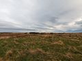
| − | + | Image:PXL_20231217_115541829.jpg | the view | |
| + | Image:PXL_20231217_115545483.jpg | the other view | ||
| + | </gallery> | ||
Revision as of 20:40, 17 December 2023
Location
In a small field near Loch of Strathbeg
Participants
Plans
To find the geohash
Expedition
After an aborted attempt at archery in Peterhead, I drove to the RSPB car park and made the short walk here. It was across a field first, then over a small barbed wire fence to get to ground zero. Some agility needed but otherwise a very short walk. I believe this is the first log on this site for this graticule :)
Tracklog
to follow when I recover my google account and download the data
Photos
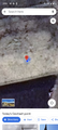
map screenshot
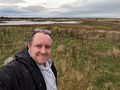
me at GZ
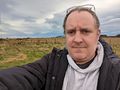
still me at GZ
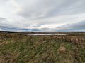
the view
the other view


