Difference between revisions of "2020-12-12 26 -98"
From Geohashing
m |
m |
||
| Line 10: | Line 10: | ||
== Participants == | == Participants == | ||
| − | *[[User: | + | *[[User:Lightrider|LightRider]] |
== Expedition == | == Expedition == | ||
| − | *I was able to drive through the point since it was smack dab in the middle of the freeway. -- [[User: | + | *I was able to drive through the point since it was smack dab in the middle of the freeway. -- [[User:Lightrider|LightRider]] ([[User talk:Lightrider|talk]]) [https://openstreetmap.org/?lat=26.22504510&lon=-98.33035820&zoom=16&layers=B000FTF @26.2250,-98.3304] 15:11, 13 December 2020 (CST) |
== Photos == | == Photos == | ||
Latest revision as of 19:20, 26 February 2024
| Sat 12 Dec 2020 in 26,-98: 26.1882211, -98.2228658 geohashing.info google osm bing/os kml crox |
Location
This Geohash is located on Interstate 2 in McAllen.
Participants
Expedition
- I was able to drive through the point since it was smack dab in the middle of the freeway. -- LightRider (talk) @26.2250,-98.3304 15:11, 13 December 2020 (CST)
Photos
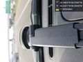
The point wizzed by at 60 mph. @26.2251,-98.3305
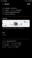
Exif for the above shot for proof.

