Difference between revisions of "2024-03-16 28 -82"
From Geohashing
(→Photos) |
|||
| Line 20: | Line 20: | ||
<gallery> | <gallery> | ||
File:Image 20240316 28 -81 Improv-1.jpg|thumb|The Plan | File:Image 20240316 28 -81 Improv-1.jpg|thumb|The Plan | ||
| − | + | File:20240316_28_-81_Tracks.jpg|thumb|Actual Tracking | |
</gallery> | </gallery> | ||
Revision as of 20:27, 18 March 2024
| Sat 16 Mar 2024 in 28,-82: 28.5336939, -82.4858968 geohashing.info google osm bing/os kml crox |
Location
A grassy berm between the sidewalk and Cortez Boulevard in Spring Hill, Florida
Participants
Plans
Two GeoHashes in one day using a route calculated as if I was bicycling (est 15.5 hours for 186 miles) using my car (approx 4.5 hours for 173 miles)
Expedition
Photos

The Plan
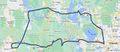
Actual Tracking

