Difference between revisions of "2024-08-14 52 5"
From Geohashing
Coyotebush (talk | contribs) ([live picture]Disagreement [https://openstreetmap.org/?mlat=52.01357222&mlon=5.91686389&zoom=16 @52.0136,5.9169]) |
Coyotebush (talk | contribs) ([live picture]Hashers [https://openstreetmap.org/?mlat=52.01357500&mlon=5.91684722&zoom=16 @52.0136,5.9168]) |
||
| Line 38: | Line 38: | ||
Image:2024-08-14_52_5_coyotebush_1723662756244.jpg|Disagreement [https://openstreetmap.org/?mlat=52.01357222&mlon=5.91686389&zoom=16 @52.0136,5.9169] | Image:2024-08-14_52_5_coyotebush_1723662756244.jpg|Disagreement [https://openstreetmap.org/?mlat=52.01357222&mlon=5.91686389&zoom=16 @52.0136,5.9169] | ||
| + | |||
| + | Image:2024-08-14_52_5_coyotebush_1723662767174.jpg|Hashers [https://openstreetmap.org/?mlat=52.01357500&mlon=5.91684722&zoom=16 @52.0136,5.9168] | ||
</gallery> | </gallery> | ||
Revision as of 19:12, 14 August 2024
| Wed 14 Aug 2024 in 52,5: 52.0135924, 5.9168611 geohashing.info google osm bing/os kml crox |
Location
In the woods just outside the Netherlands Open Air Museum in Arnhem.
Participants
Plans
Meet at the nearest bus stop at 17:20.
Expedition
- We're on a bus in the rain -- Coyotebush (talk) @51.9861,5.9067 17:12, 14 August 2024 (GMT+02:00)
Photos
Waiting for a bus @51.9839,5.9005

Goodbye bus @52.0077,5.9140
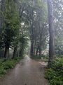
Main path
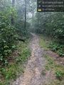
Side path @52.0135,5.9176
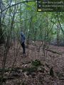
Disagreement @52.0136,5.9169
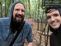
Hashers @52.0136,5.9168


Achievements