Difference between revisions of "2024-08-24 53 8"
From Geohashing
Beardygrade (talk | contribs) ([retro picture]Beardygrade at the right spot. [https://openstreetmap.org/?mlat=53.17148333&mlon=8.56872500&zoom=16 @53.1715,8.5687]) |
Beardygrade (talk | contribs) ([retro picture]Some serious wheather looming ahead. [https://openstreetmap.org/?mlat=53.13973611&mlon=8.25205556&zoom=16 @53.1397,8.2521]) |
||
| Line 39: | Line 39: | ||
Image:2024-08-24_53_8_beardygrade_1724713417826.jpg|Beardygrade at the right spot. [https://openstreetmap.org/?mlat=53.17148333&mlon=8.56872500&zoom=16 @53.1715,8.5687] | Image:2024-08-24_53_8_beardygrade_1724713417826.jpg|Beardygrade at the right spot. [https://openstreetmap.org/?mlat=53.17148333&mlon=8.56872500&zoom=16 @53.1715,8.5687] | ||
| + | |||
| + | Image:2024-08-24_53_8_beardygrade_1724713519752.jpg|Some serious wheather looming ahead. [https://openstreetmap.org/?mlat=53.13973611&mlon=8.25205556&zoom=16 @53.1397,8.2521] | ||
</gallery> | </gallery> | ||
Revision as of 23:05, 26 August 2024
| Sat 24 Aug 2024 in 53,8: 53.1421114, 8.4906792 geohashing.info google osm bing/os kml crox |
Location
The geohash was located in a wet, grassy rural landscape (Hiddigwardermoor) between Hude and the small river Ollen. It was more or less in the center of a field accessible from the road.
Participants
Plans
Expedition
Tracklog
Photos

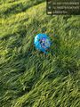
Proof of reaching the geohash.
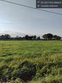
The wet, grassy field underlying the geohash.
Perhaps some airborne geohasher reached the spot prior to me? @53.1893,8.5470
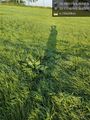
Beardygrade at the right spot. @53.1715,8.5687
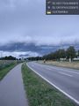
Some serious wheather looming ahead. @53.1397,8.2521


Achievements