Difference between revisions of "2024-10-13 65 25"
(Created page with "{{subst:expedition}}") |
|||
| Line 1: | Line 1: | ||
| − | + | {{meetup graticule|date=2024-10-13|lat=65|lon=25}} | |
| + | == Location == | ||
| + | In a forest in Isokangas nature reserve. | ||
| − | [ | + | The point on a topographic map: [https://kripakko.neocities.org/geohash_maplink?{{#replace:{{SUBPAGENAME}}| |_}}K] |
| − | |||
| − | |||
| − | |||
| − | |||
| − | |||
| − | |||
| − | |||
| − | |||
== Participants == | == Participants == | ||
| − | + | *[[User:Kripakko|Kripakko]] | |
| − | |||
| − | == | + | == Expedition == |
| − | + | Success! Report will follow... | |
| − | + | According to the GPS receiver, I cycled 45.7 kilometres and walked 2.5 kilometres during the trip. | |
| − | |||
== Tracklog == | == Tracklog == | ||
| − | < | + | <span style="color:#0000ff">Blue = cycling</span>, |
| + | <span style="color:#ff0000">red = walking</span>. | ||
| + | |||
| + | {{Tracklog|2024-10-13 65 25 tracklog.gpx}} | ||
== Photos == | == Photos == | ||
| − | < | + | <gallery perrow="14"> |
| − | Image:2024- | + | Image:2024-10-13_65_25_01-road.jpg | At the beginning of Sanginjoentie road. |
| − | -- | + | Image:2024-10-13_65_25_02-river.jpg | View to the Sanginjoki river. |
| − | + | Image:2024-10-13_65_25_03-retro_gpsr.jpg | Visiting the [[2024-10-14 65 25|reverse retrohash]]: the GPS receiver at the point. | |
| + | Image:2024-10-13_65_25_04-retro-area.jpg | Visiting the [[2024-10-14 65 25|reverse retrohash]]: the surroundings. | ||
| + | Image:2024-10-13_65_25_05-huntingsign.jpg | There may be moose hunting in this area currently... good to know. | ||
| + | Image:2024-10-13_65_25_06-info1.jpg | Information board about the nature reserve, also in English. | ||
| + | Image:2024-10-13_65_25_07-info2.jpg | Another information board about mire restoration in the area. | ||
| + | Image:2024-10-13_65_25_08-parkingarea.jpg | Where I parked the bicycle and continued on foot. | ||
| + | Image:2024-10-13_65_25_09-gpsr1.jpg | Proof of location. | ||
| + | Image:2024-10-13_65_25_10-gpsr2.jpg | Proof of date and time. | ||
| + | Image:2024-10-13_65_25_11-selfie.jpg | Stupid Grim™ | ||
| + | Image:2024-10-13_65_25_12-forest.jpg | Calm forest in the nature reserve. | ||
| + | Image:2024-10-13_65_25_13-lake.jpg | View to lake Isonkankaanjärvi. | ||
| + | Image:2024-10-13_65_25_14-colours.jpg | Trees in autumn colours in the city. | ||
</gallery> | </gallery> | ||
== Achievements == | == Achievements == | ||
| − | {{ | + | {{Land geohash | name = [[User:Kripakko|Kripakko]] | latitude = 65 | longitude = 25 | date = 2024-10-13}} |
| − | + | {{Bicycle geohash | name = [[User:Kripakko|Kripakko]] | latitude = 65 | longitude = 25 | date = 2024-10-13 | distance = 45.7 km | bothways = true}} | |
__NOTOC__ | __NOTOC__ | ||
| − | + | ||
| − | |||
[[Category:New report]] | [[Category:New report]] | ||
| − | <!-- | + | <!-- |
| − | |||
| − | |||
| − | |||
| − | |||
| − | |||
[[Category:Expeditions]] | [[Category:Expeditions]] | ||
| − | |||
[[Category:Expeditions with photos]] | [[Category:Expeditions with photos]] | ||
| − | [[Category: | + | [[Category:Coordinates reached]] |
--> | --> | ||
| − | |||
| − | |||
| − | |||
| − | |||
| − | |||
| − | |||
| − | |||
| − | |||
| − | |||
| − | |||
| − | |||
| − | |||
| − | |||
| − | |||
| − | |||
| − | |||
| − | |||
Revision as of 18:37, 14 October 2024
| Sun 13 Oct 2024 in 65,25: 65.0049865, 25.8765568 geohashing.info google osm bing/os kml crox |
Location
In a forest in Isokangas nature reserve.
The point on a topographic map: [1]
Participants
Expedition
Success! Report will follow...
According to the GPS receiver, I cycled 45.7 kilometres and walked 2.5 kilometres during the trip.
Tracklog
Blue = cycling, red = walking.
Photos
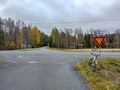
At the beginning of Sanginjoentie road.
View to the Sanginjoki river.
Visiting the reverse retrohash: the GPS receiver at the point.
Visiting the reverse retrohash: the surroundings.
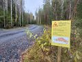
There may be moose hunting in this area currently... good to know.
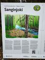
Information board about the nature reserve, also in English.
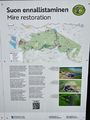
Another information board about mire restoration in the area.
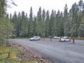
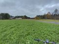
Where I parked the bicycle and continued on foot.
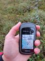
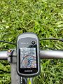
Proof of location.
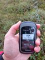
Proof of date and time.
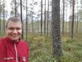
Stupid Grim™
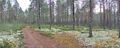
Calm forest in the nature reserve.
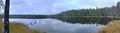
View to lake Isonkankaanjärvi.
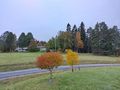
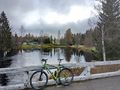
Trees in autumn colours in the city.


Achievements
Kripakko earned the Land geohash achievement
|
Kripakko earned the Bicycle geohash achievement
|