Difference between revisions of "2008-07-28 48 -123"
imported>Robyn (ribbon template) |
imported>Robyn (photos) |
||
| Line 18: | Line 18: | ||
I didn't stick around because some backyard dogs were going insane with barking at me. I did find another way out so I didn't have to go back through the brambles. Canadian customs on the way home was also relaxed. She looked at the present for my brother, but trusted that I had brought it with me. | I didn't stick around because some backyard dogs were going insane with barking at me. I did find another way out so I didn't have to go back through the brambles. Canadian customs on the way home was also relaxed. She looked at the present for my brother, but trusted that I had brought it with me. | ||
| − | This earned me the [[Border geohash]] achievement, and as far as I know was the first successful geohash in the [[Victoria, British Columbia|Victoria]] graticule. | + | This earned me the [[Border geohash]] achievement, and as far as I know was the first successful geohash in the [[Victoria, British Columbia|Victoria]] graticule. As frequently occurs I forgot to take my own picture, except for some shots of the blood dripping down my legs from the brambles, and no one wants to see my hairy legs. |
| − | + | <gallery widths="200px" heights="200px" perrow="2"> | |
| + | Image:2008-07-28 48 -123.borderS.JPG|The border crossing heading south to the US. | ||
| + | Image:2008-07-28 48 -123.brambles.JPG|Some of the brambles I walked through. They were nastier than this looks, though. | ||
| + | Image:2008-07-28 48 -123.point.JPG|Closest to the point that I could get a GPS signal. It appears so bright because I used the flash. It's actually quite dark in the trees. | ||
| + | Image:2008-07-28 48 -123.trees.JPG|The geohash, under the tree canopy. | ||
| + | Image:2008-07-28 48 -123.border.jpg|The Canadian border on the way home. | ||
| + | </gallery> | ||
{{Border geohash achievement | {{Border geohash achievement | ||
Revision as of 12:32, 29 July 2008
| Mon 28 Jul 2008 in Victoria: 48.9856292, -123.0799660 geohashing.info google osm bing/os kml crox |
The geohash fell on Point Roberts, a point of land notable because although it is in North America, in the United States, and not on an island, it borders no other state. It is accessible only by water (and does have a large marina) or by driving through Canada. And drive I did, breaking my own no-driving-to-geohashes rule, as I was visiting my brother, who lives only a few kilometres away on the Canadian side of the border, and carrying a fragile gift that I didn't want to schlep by bus and bicycle.
The border crossing was uneventful. Because it's such a small slice of the US, and won't get you anywhere, the border guards are pretty relaxed. They asked me what colour my car was, which was odd. I guess to check if I had stolen it. When they asked what I was going to be taking pictures of, I gestured at the GPS on the dashboard and explained that it was "an assigned point for a distributed art project."
The geohash was only 80 m from a rural road, but it sure made me work for it, being thick with brambles and trees. It was on a narrow sliver of property between a No Trespassing private camp and the back fences of some homes, and in this area blackberry bushes grow head high in any untended spot. I suspect it was an unsold lot, cleared once, and then allowed to run wild.
As I thrashed my way through brambles I could hear other people in the woods, and I hoped they were geohashing too, but what was I going to say, "Hey, are you from the Internet?" When I got past the brambles into denser woods I kept losing the GPS signal, but I kept walking in the direction the GPS had been indicating, and counting my steps. I had to go a little past the hash to a clearing to get reception again.
I didn't stick around because some backyard dogs were going insane with barking at me. I did find another way out so I didn't have to go back through the brambles. Canadian customs on the way home was also relaxed. She looked at the present for my brother, but trusted that I had brought it with me.
This earned me the Border geohash achievement, and as far as I know was the first successful geohash in the Victoria graticule. As frequently occurs I forgot to take my own picture, except for some shots of the blood dripping down my legs from the brambles, and no one wants to see my hairy legs.
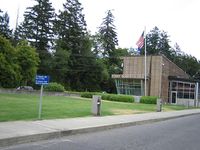
The border crossing heading south to the US.

Some of the brambles I walked through. They were nastier than this looks, though.
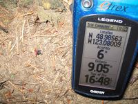
Closest to the point that I could get a GPS signal. It appears so bright because I used the flash. It's actually quite dark in the trees.
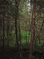
The geohash, under the tree canopy.
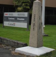
The Canadian border on the way home.


Robyn earned the Border geohash achievement
|