2010-03-28 45 -123
| Sun 28 Mar 2010 in 45,-123: 45.7626321, -123.1763295 geohashing.info google osm bing/os kml crox |
Location
North of Hwy 26, Near Bacona, Oregon, in the roadway
Participants
Plans
Jim's planning on going. He's also dreaming about continuing on to Clatskanie, but he'd have to get up fairly early to do that. (But, not as early as those who left the day before to get to Idaho!)
Expedition
Well, I didn't get up early to go geohashing and then head on over to the Columbia, which turned out to be just as good. I found the initial roads I was looking for, but I missed the turn off of the paved road. Partly, I expected that a large green sign with two street names would be a little before the street itself, especially if it is a 55MPH highway. But I forgot I'm in Oregon.
So, I turned around and headed back to the find what looked like a person's driveway, but really was the road to the hashpoint. The soon-to-turn-to-gravel, one lane, windy road to the hashpoint. As I'm driving up it, I'm thinking "I have a bad feeling about this" and "I wonder where I can turn around without plunging off the rather steep slope to my right."
I hit one road off to the left, but it seemed too soon, and it had a locked gate and a sign that appeared to forbid access, so I continued on. The next road ended quickly with a locked gate, and didn't seem to head in the right direction, so I went back.
Closer inspection of the sign on the gate revealed that it didn't prohibit access except when we'd be in the way or in danger. Weekends were okay, so I changed footgear and headed in. I started up the fairly steep hill and found soon that the GPS was pointing to the left into very dense forest. Clearly the other gate was the way to go, but I was hungry and tired, and the car was thirsty, and I didn't remember the other gate was being quite a friendly as this one, so I gave up and headed out.
Photos
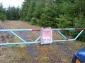
The first gate
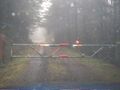
The second gate (parsam gate?)
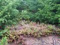
The brush the GPS wanted me to head through
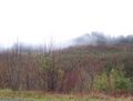
A view of the area


