2011-07-18 55 12
| Mon 18 Jul 2011 in 55,12: 55.6128470, 12.4626463 geohashing.info google osm bing/os kml crox |
Location
Todays hash fell in the Avedøre Holme industrial comlex south of Hvidovre in what turned out to be a military facility.
Participants
Plans
Seeing how the hashpoint was only a short drive in the lovely weather off from the place I had arranged a pickup of a tape recorder, I decided to give it a shot.
Expedition
After packing a towel and some rope in the globe compartment of my vespa, I sat out towards the industrial complex of avedøre holme. After a couple of kilometers, I had to make a stop to fill up the tank. From here on, it was plain sailing through the Copenhagen suburbs till I arrived at a broad deserted road through running past old factories and modern office buildings. Here I was within throwing distance of the hashpoint, but an unforseen obstacle awaited me when I turned the corner to what looked like an entrance: a sign saying 'military area, no entry'. What rotten luck. What had looked like an easy hash turn out, once again, to be unreachable. Just to make sure, I drove round the entire complex, but every gate bore the same signs. Thus, without having reached the point, I gave up and drove off on a short tour of the area, looking for the factories where I, years before, used to drive a forklift (even though I never actually got around to take the license). Every street looked the same, but different than they did then, so I repeated my previous lack of success and managed not to find the place. Meanwhile, the time had continued its countdown towards doomsday, bringing it close to my appointed tape recorder pickup, so I pointed my vespa perpendicular to the setting sun and drove off.
Photos
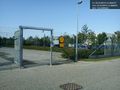
As it turns out, todays geohash is located inside a military facility... @55.6124,12.4608


when there is a man-made obstacle between you and the target