2015-07-17 49 11
From Geohashing
Revision as of 13:45, 17 July 2015 by imported>Schnatterfleck (Another watering device. In the background you can make out the tower of Nuremberg's airport. [http://www.openstreetmap.org/?lat=49.50320000&lon=11.05060000&zoom=16&layers=B000FTF @49.5032,11.0506])
| Fri 17 Jul 2015 in 49,11: 49.5124496, 11.0433368 geohashing.info google osm bing/os kml crox |
Location
Participants
Plans
Expedition
Tracklog
Photos
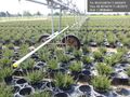
Massively parallel automated plant pot watering @49.5014,11.0523
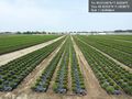
Enough little patio greenery for the better part of southern Germany @49.5032,11.0508
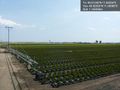
Another watering device. In the background you can make out the tower of Nuremberg's airport. @49.5032,11.0506


Achievements