2012-07-13 40 -74
From Geohashing
Revision as of 21:52, 17 July 2012 by imported>Jevanyn ([retro picture] Closest crossroads, just for reference [http://www.openstreetmap.org/?lat=40.56280000&lon=-74.69910000&zoom=16&layers=B000FTF @40.5628,-74.6991])
| Fri 13 Jul 2012 in 40,-74: 40.5662695, -74.7369868 geohashing.info google osm bing/os kml crox |
Location
Participants
Plans
Expedition
- This geohash is only a few miles from home for me, so I drove by while out running errands with the baby. -- Jevanyn 17:48, 17 July 2012 (EDT)
Tracklog
Photos
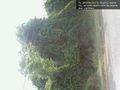
Geohash is right under that tree, give or take a few feet. @40.5628,-74.6991
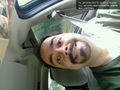
I've been practicing my Silly Grin &tm; @40.5628,-74.6991
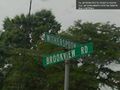
Closest crossroads, just for reference @40.5628,-74.6991


Achievements