| Sun 28 Apr 2013 in 51,-0: 51.2958254, -0.4715725 geohashing.info google osm bing/os kml crox |
Location
Participants
Plans
Walk from Staines, taking a scenic route, until I reach the coordinates. It looked like a nice day and there was nothing of immediate urgency that needed doing elsewhere. Once there, send in an update via the andriod "Geohash Driod" app, then find a pub to get something to eat and take a leisurely walk back home.
Expedition
- Reached the coords. Muddy ditch by the side of a narrow country lane. Walked +20 miles to get here, but satisfied - now, to get back. :-) -- KennethCC (talk) @51.2958,-.4717 10:38, 28 April 2013 (EDT)
Tracklog
Photos
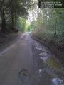
In this puddle; as near as can be made out. @51.2958,-.4716

Obligatory selfie. @51.2958,-.4716


Achievements