2022-02-19 -37 144

| Sat 19 Feb 2022 in -37,144: -37.1434851, 144.9612001 geohashing.info google osm bing/os kml crox |
Location
In a sheep paddock near Broadford
Participants
John
Bridget
Expedition
We were planning on having a drive to have a walk in the bush somewhere anyway that day but we were faced with the problem of picking a particular destination. Bridget had taken a close interest in my recent geohashing expeditions but was yet to make it to a hash herself, so she was very happy to accept my suggestion that we try to find somewhere that looked nice to walk in the vicinity of the hash, which would allow us to make an attempt at the hash on the same trip.
So, we had a peruse of the map around the hashpoint, and spotted a Mt Piper Conservation Area, and a quick google confirmed that there were indeed a couple of nice little walks you could do there - either a climb to the top or a loop around the base of the mountain. It was decided, so we set off, making our way from Ascot Vale onto the Hume, before taking an exit that would take us through Wallan and Kilmore and up towards Broadford.
As we neared Broadford we decided that we would attempt the hash first before heading for Mt Piper, as a result we turned on to the Kilmore-Glenaroua Rd. This was a very pleasant quiet dirt road, lined with eucalypts most of the way, and as we drove along it we passed a couple of horseracing stud farms. As we drove further along, getting close to the hash, it became more open paddocks on the left, which we presumed to be the same property as where the hash itself was located. But we were on the east side, and best access to the hash was to be from the west, where it was not far from the road. So we made a couple of left turns following the edge of this property, and soon we were on the west side, and as close as we could get to the hash by road. As we pulled over we were less than 100m from the hashpoint.
Once we were up the embankment at the side of the road, we were met with two layers of wire fencing. The first was a low barbed wire fence in a rusty state of disrepair, and at one point the top line of barbed wire was broken leaving a gap, so it was very easy to step over here. The second fence was more intimidating however, not barbed, but looking like it could be electrified. The paddock beyond the fence looked deserted however, and with no obvious overlooking buildings to be concerned by. We closely inspected the second fence, but couldn't hear any faint buzzing, and couldn't detect any sign of electrification by holding a leaf up to the wire (which google told us was a safe way of determining fence electrification), so we tentatively concluded that although the fence we possibly electrifiable it didn't seem to be switched on. A timid touch with a finger confirmed that the fence was safe.
We stepped through the wire and entered the paddock. At this point we still had around 80m to go across longish dry yellow grass. The first 50m or so was up a rise, meaning that we weren't quite sure what we'd see in the rest of the paddock once we were at the top, maybe some dangerous animals, maybe a farmer who would take exception to our being there. As it turned out though all there was was a group of sheep huddling in the shade of a couple of trees about 100m further on, and they didn't seem too perturbed by our presence. So we reached the hash with ease, screenshotted the gps location, snapped a couple of pics and headed back to the car, satisfied in the knowledge of a hash well done.
Tracklog
Photos

Gps proof
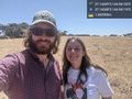
At the hash! @-37.1435,144.9612
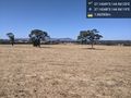
Sheep huddling in the shade close by in the same paddock as the hash @-37.1435,144.9612


Achievements