File:20230708 29 -95 DrivingThroughTheGeohash.png
From Geohashing
Revision as of 16:32, 10 July 2023 by Enjoythecode (talk | contribs)

Size of this preview: 270 × 600 pixels. Other resolutions: 108 × 240 pixels | 1,080 × 2,400 pixels.
Original file (1,080 × 2,400 pixels, file size: 2.47 MB, MIME type: image/png)
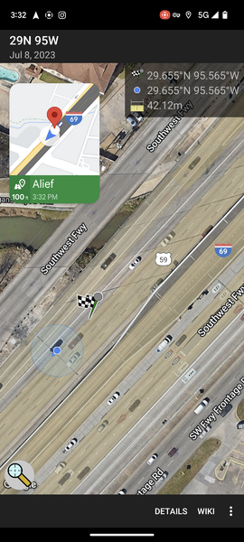
A screenshot of Enjoythecode and their partner visiting the 2023-07-08 geohash in the 29N 95W graticule. The geohash is on a freeway, and the location dot it some 40m ahead of the geohash coordinates, implying that the geohashers drove through the geohash point successfully (they did).
File history
Click on a date/time to view the file as it appeared at that time.
| Date/Time | Thumbnail | Dimensions | User | Comment | |
|---|---|---|---|---|---|
| current | 16:32, 10 July 2023 | | 1,080 × 2,400 (2.47 MB) | Enjoythecode (talk | contribs) |
- You cannot overwrite this file.
File usage
The following 2 pages link to this file: