2009-12-14 -37 145
From Geohashing
Revision as of 05:40, 14 December 2009 by imported>MykaDragonBlue (maplarity)
| Mon 14 Dec 2009 in -37,145: -37.4375906, 145.5675740 geohashing.info google osm bing/os kml crox |
Contents
Location
Black Saturday Fire Zone, between Kinglake and Marysville
Participants
Plans
I'm going to drive up there after work, along the Maroondah Highway until just before the Marysville turnoff, then into the bush along the tracks, where, conditions dependant, I should be able to get to within a few hundred meters of the hash before taking a short stroll.
Planning maps
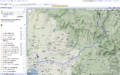
whole way
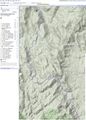
off the beaten track... well, off the paved track anyway
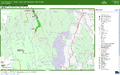
Closeures etc in the hash area. Crosshatching indicates a burnt area.


