2011-09-30 48 -88
From Geohashing
Revision as of 23:19, 30 September 2011 by imported>Jack1254 (Created page with "{{subst:Expedition |lat = 48 |lon = -88 |date = 2011-09-30 }} == Location == Located about 100m from the shore of Lake Superior near Pass Lake Rd. == Participants == [[User:...")
| Fri 30 Sep 2011 in 48,-88: 48.5594839, -88.7521347 geohashing.info google osm bing/os kml crox |
Location
Participants
Plans
Expedition
Tracklog
Photos
Achievements
Location
Located about 100m from the shore of Lake Superior near Pass Lake Rd.
Participants
Expedition
After turning onto a dirt road off Highway 587, I hit a gate. Fearing the worst that my drive out was in vein, I got out an looked around. Thankfully there was a sign pointing to a path way around the gate for hikers. Alright, the last couple hundred metres would be on foot! The path ended at the shore of Lake Superior, at which point I was greeted by a fantastic view! Eventually I trudged into the forest. I came across an old abandoned boat only footsteps from my target, which seemed sort of fateful. All in all, an easy but enjoyable trip!
Gallery
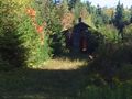
Abandoned building
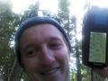
Stupid Grin
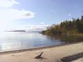
Lake Superior


