2012-02-10 59 17
| Fri 10 Feb 2012 in 59,17: 59.5617862, 17.4896871 geohashing.info google osm bing/os kml crox |
Location
In a frozen field SW of Bålsta right next to a tiny road.
Participants
Plans
Plans were to drive up with TheChef's Jag and have a bit of a road trip.
Expedition
TheChef came and picked Carl-Johan up in TheChef's Jag and we went on a road trip. Carl-Johan was the designated driver since he likes to drive in Stockholm and TheChef doesn't. Got out on the E4 around Lilla Essingen and the traffic was almost still around the construction work near Norrtull. Continued upp to Upplands Väsby and out on the E18. By now we had gotten past all the Friday traffic and things went smoothly. Turned off just before Bålsta. Of course the GPS sent us up the wrong way since that was the closest houses, but we wanted the field and had to backtrack a bit.
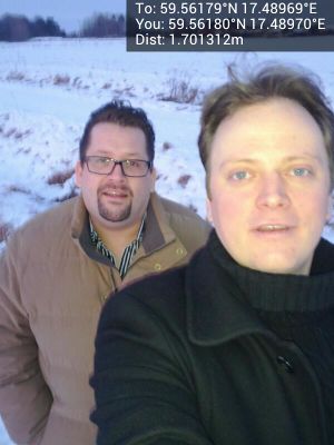
On this tiny frozen road we got closer to the hash, and eventually got to 6 m from it. Got out of the car and took some nice pics. The sun was just setting so it was beautiful but cold.
- In a frozen field near Bålsta. -- Carl-Johan @59.5617,17.4897 16:37, 10 February 2012 (CET)
Before we started freezing too much we turned back towards the City and went and had a very nice dinner at Kalaset Corner where TheChef usually works, but not tonight.
Photos
TheChef and Carl-Johan at the hash @59.5618,17.4897
Panorama 2 @59.5618,17.4898
Marker @59.5634,17.4926
TheChef @59.5634,17.4926
Achievements
TheChef and Cjk earned the Land geohash achievement
|
TheChef and Cjk earned the Frozen Geohash Achievement
|


