2012-07-27 59 12
From Geohashing
Revision as of 22:19, 27 July 2012 by imported>Cjk (The logging machines have used this path [http://www.openstreetmap.org/?lat=59.29410000&lon=12.63300000&zoom=16&layers=B000FTF @59.2941,12.6330])
| Fri 27 Jul 2012 in 59,12: 59.2910436, 12.6299855 geohashing.info google osm bing/os kml crox |
Location
Participants
Plans
Expedition
- In Karlstad -- Cjk @59.3834,13.4762 18:46, 27 July 2012 (CEST)
- Damn swamp, feet wet, deflowered -- Cjk @59.2911,12.6300 19:41, 27 July 2012 (CEST)
Tracklog
Photos

Made it, with Campanja T-shirt @59.2911,12.6299
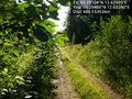
Only 448 m to go from this unknown road @59.2948,12.6328
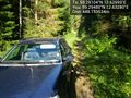
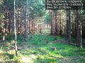
The car in these woods @59.2948,12.6328
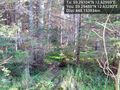
It's in there somewhere @59.2948,12.6328
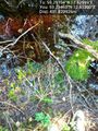
It was a swamp, tried it, tried to jump back, landed in this ditch and soaked my shoes so wtf, let's just cross this swamp! @59.2946,12.6330
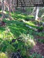
Marsh, swamp, wet feet. @59.2946,12.6330
The logging machines have used this path @59.2941,12.6330


Achievements