2013-01-10 30 -93
| Tue 10 Jan 2012 in 30,-93: 30.5915681, -93.1394323 geohashing.info google osm bing/os kml crox |
Location
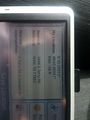
Hash co-ordinates given by the small hash inquiry tool as 30.100240 North, 93.958631 West. Just slightly off a set of accesible train tracks near Vidor, Texas. Started the expedition in Sam Houston Jones State Park, just outside Lake Charles, Louisiana. While we did not complete the Hash exactly we got pretty close at 30.10073 North, 93.96047 West, within sight of the geohash.
Participants
Plans
Expedition
Tracklog
Photos

Breakfast of champions at the start of the hash with Carmel.
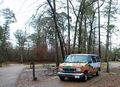
Our ride/Home for the hash and our road trip
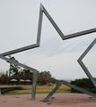
The van through the lone star at the texas border.
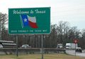
Welcome to Texas

Toby with the hash point just down the tracks in the background.
Part of the reason the hash wasn't successful.
The closest we dared to go....

Toby and Carmel near the hash point.
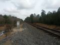
Better photo of the hash point.
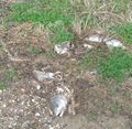
More reasons we didn't quite make it.


Achievements