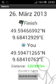
2013-03-26 49 9
From Geohashing
Revision as of 13:51, 27 March 2013 by imported>Chemluth
| Tue 26 Mar 2013 in 49,9: 49.5946699, 9.6841293 geohashing.info google osm bing/os kml crox |
Location
Above the Tauber near Distelhausen.
Participants
Plans
I did not really plan it I just noticed that I would pass throuh Distelhausen anyway and decidet to give it a try.
Expedition
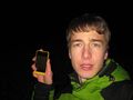
I started walking at the football (soccer for our american friends) field and crossed a brigde over the river Tauber. I was already pritty dark and I didn´t find find the way Saw on the satelite picture. So I just went up the hill following the GPS. I crossed a railroad track and hat to make my way through thorny bushes and climb the steep hill towards the forrest. The hashpoint was about 10 Meters inside the woods.
Tracklog
Photos
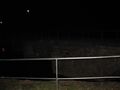
Bridge over the Tauber
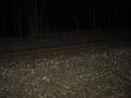
The railway tracks I crossed


Achievements