2013-06-13 53 -2
From Geohashing
Revision as of 09:42, 13 June 2013 by imported>Angel ([live picture] No public access? The hash is in those woods, and the map shows a track across this field; but its not a right of way, so the farmer is quite entitled to have blocked it off. [http://www.openstreetmap.org/?lat=53.99550000&lon=-2.80616000...)
| Thu 13 Jun 2013 in 53,-2: 53.9996036, -2.8043952 geohashing.info google osm bing/os kml crox |
Location
Old Park Wood, just off the canal outside Galgate; an easy hour walk from Lancaster (I hope)
Participants
Plans
Expedition
Tracklog
Photos
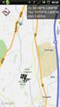
Looks like this one shouldn't be too hard to get to @54.0213,-2.8084
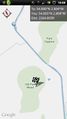
Hmm, not so sure if there's any access from here @54.0041,-2.8067
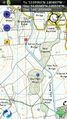
The OS map looks a bit more promising, though - @54.0035,-2.8057
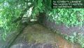
Well, there's the bridge. Unfortunately, lots of barbed wire between the path under and the path over @54.0017,-2.8027
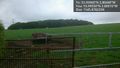
No public access? The hash is in those woods, and the map shows a track across this field; but its not a right of way, so the farmer is quite entitled to have blocked it off. @53.9955,-2.8062


Achievements